Commentary: Replenishing Groundwater in the San Joaquin Valley

This commentary was published in the Sacramento Bee on April 18, 2018.

California’s biggest agricultural region also has the state’s biggest groundwater deficit, which has long-term consequences for the region’s economy and farming.

The San Joaquin Valley—where decades of unchecked pumping has depleted reserves, resulting in a long-term deficit of nearly 2 million acre-feet per year—has about a generation to bring its groundwater use into balance to comply with the state’s Sustainable Groundwater Management Act. Storing more water underground through “groundwater recharge” can help, reducing the deficit by about a quarter.

Read the full commentary on sacbee.com 

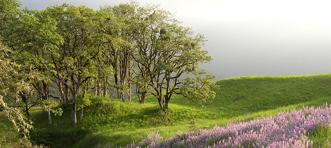
Image above courtesy of Jonathan Parker, Kern Water Bank Authority

3 Things to Know about California Droughts

The erratic weather in recent months—a dry winter followed by “atmospheric rivers” that packed a punch in March and April, capped by a poor report on the state’s snowpack—hasn’t exactly offered a clear picture for drought watchers. In fact, there is no universal definition of when a drought begins or ends. Here are three things about droughts that every Californian should know.

Rain, snow, and water in storage are the conditions that define a drought in California.

Technically speaking, a drought is simply having less precipitation than normal. But California’s climate is so variable—indeed, it’s the most variable in the nation—that our “normal” is often either very wet or very dry. We also have an annual, seasonal “drought” from late spring through early fall.

To cope with this variability, we’ve developed a massive storage system and conveyance networks to move water to places where it is scarce and demand is high. Thanks to this elaborate water system, California can face one or two much drier-than-normal years without major disruptions.

California’s mountain snowpack has historically provided “free” seasonal storage for meeting summer irrigation needs. About a third of the state’s annual water supply is stored as snow in the Sierra headwaters. Large reservoirs across the state capture melting snow and release it during our dry summers. Experts have recently begun referring to a new type of drought—“snow drought”—to define years when reduced overall precipitation coincides with unusually warm winters. The winter of 2015 was a good example, with the all-time lowest snowpack in recorded history. Unfortunately, this is becoming more frequent due to the warming climate, and it has big implications for water management because our current system isn’t designed for this shift from snow to rain.

Accounting for these conditions, most of California is not expected to be in a drought this year. Precipitation levels have been low—somewhere between “dry” and “below normal”—and the snowpack is about half of average, but the large reservoirs are still in good shape after the 2017 deluge.

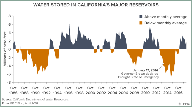
But this might change relatively quickly. As the figure shows, during successive dry years we rapidly draw down storage in reservoirs. By year two or three of a drought, reservoir releases are cut back and water scarcity becomes a problem, particularly in many agricultural regions. Groundwater helps reduce the impacts of drought, but it isn’t sufficient for extended droughts, and significant cutbacks in water use are required.
Drought vulnerability varies across the state.

California suffers a statewide drought only rarely, and the impacts of drought vary. Southern California is a relatively dry region, but it imports half of its water from Northern California and the Colorado River basin, both of which provide more reliable supplies. The central coast, which is not well connected to the statewide water system, relies much more on local precipitation and storage, which means it has a higher vulnerability to drought than other regions. In many areas, groundwater helps offset the loss of surface water during droughts. But long-term overreliance on groundwater—especially in the San Joaquin Valley—has led to negative effects, including dry wells, sinking lands, increased costs of groundwater pumping, and reduced supplies for future droughts.

Planning and preparing for drought can make a big difference. Our research has found that California’s cities and suburbs are the most drought-resilient areas of the state, thanks to significant local and regional investments in diversified water supplies.

Drought is not our only—or biggest—water problem.

Droughts worsen many of California’s water problems and heighten awareness of a number of other issues. But drought is not the underlying cause of critical, chronic problems facing California, such as difficulties accessing safe drinking water, our aquatic ecosystem crisis, or the unsustainable use of groundwater. Perhaps we put too much emphasis on drought―which is, after all, a natural feature of the state’s climate―and not enough on other critical issues.

Ecosystems Need Groundwater Too

Groundwater is a critical resource for most living things in California. But while human communities can increase groundwater pumping when surface supplies diminish during droughts, ecological systems often have no backup supply. We talked to Sandi Matsumoto, associate director of the Nature Conservancy’s California Water Program, about determining which ecosystems are particularly dependent on groundwater and what can be done to help them cope with dropping water levels.

PPIC: What are “groundwater-dependent ecosystems”?

Sandi Matsumoto: These are familiar places to everyone—wetlands, rivers, estuaries, springs, and associated plants and animals that rely on groundwater to meet some or all of their needs. They’re found in nearly all of the state’s groundwater basins and are often supported by surface waters, such as rivers and streams fed by rain or melting snow. Even deserts have them—where springs support desert oases, for example.

The Nature Conservancy has been working with California’s Departments of Water Resources and Fish and Wildlife to develop a comprehensive statewide map of vegetative indicators of groundwater-dependent ecosystems. Using plants as the prime indicators, we’ve mapped 2.2 million acres of groundwater-dependent ecosystems.

PPIC: How well do we understand the connections between groundwater and the ecosystems that depend on it?

SM: We’re definitely early in our understanding of this complex relationship. To fully understand it you’d have to get a hydrogeologist and an ecologist in the same room together—and you don’t see that pairing very often.

I like to think of rivers and streams as expressions of a healthy groundwater system. In California, rivers can flow well into summer months, long after the snowpack has melted. In areas with high groundwater levels, a lot of that river flow can come from groundwater. High levels of pumping can reverse this dynamic—when groundwater levels drop lower than the bottom of the river channel, water starts seeping into the aquifer. It’s called a “losing stream.”

Going forward, I think the Sustainable Groundwater Management Act (SGMA) will bring a much greater understanding of ecosystem conditions. By monitoring certain vegetation types we could improve our understanding even more. For example, we can look for signs of declining health in plants or changes in the number of acres of these “indicator plants.”

The trend has been a decline of groundwater-dependent ecosystems. The goal of SGMA is to stabilize things, but if groundwater sustainability agencies make a concerted effort, we may even be able to reverse the decline. For example, colleagues at the Nature Conservancy in Arizona are doing groundwater recharge projects near rivers, boosting their flow and improving conditions for riparian ecosystems. In California we’re trying to mimic seasonal wetlands by flooding farmland to support migratory birds. These kinds of projects help farmers while also providing habitat and even groundwater recharge benefits.

I also think that SGMA will force us to figure out what we care about and how to sustain those things. To get to groundwater sustainability we have to talk to each other, and experts will have to come out of their silos. If SGMA is done right, we’ll see hydrogeologists working with ecologists and other unlikely pairings. That’s what I’m most hopeful about.

How Oroville Is Changing Dam Safety in California

California’s 1,500 dams are regularly inspected and most have been safe for generations. Before last year’s Oroville Dam spillway crisis, the last dam disaster was the deadly 1928 Saint Francis Dam failure in Southern California. But the scale and drama of the Oroville crisis jolted the state into action, resulting in a stream of safety reviews, forensic analyses, and policy changes.

Within weeks of Oroville’s spillway incident, Governor Brown announced a 4-point plan to bolster dam safety and flood protection. And with the enactment of Senate Bill 92, a new dam safety regime has strengthened the state’s existing system.

We asked two experts about the lessons of Oroville for dam safety in California: Jeff Mount, a senior fellow at the PPIC Water Policy Center and an expert in hydrology and geology; and Jay Lund, director of the Center for Watershed Sciences at UC Davis, a member of the National Academy of Engineering, and an adjunct fellow at PPIC.

“First, we have to do a more complete job of assessing infrastructure,” said Lund. “We need to look for potential cascades of failures, which is what happened at Oroville. And we need to look at all of the outlet structures, which are essentially a dam’s safety valves.”

He noted that all federally regulated dams are subject to safety analysis every seven years, “yet they didn’t pick up the problems of Oroville. The lessons here are that you can never stop worrying about infrastructure and that we have to be prepared for things to fail.”

Mount seconded the need to stay vigilant, noting, “Water has a way of finding weaknesses in planning, design, and maintenance. If you miss something, eventually water will find a way to tell you so.”

Another new dam safety bill, Assembly Bill 1270, requires the state to consult with independent experts to update dam safety practices every 10 years. Lund said that will encourage the use of new kinds of technologies and practices. “But I think more important than the law itself is the culture of the people in charge of dams and dam safety, and whether they’re given the right resources and the mission to do more thorough assessments of old problems lurking in these structures.”

Mount noted that climate change is a complicating factor. “The inspections and upgrades are a good start,” he said. “But many of our dams―including Oroville―were designed more than 50 years ago. We need to evaluate how to operate them under changing hydrologic conditions.”

He added that many large dams try to fulfill multiple, conflicting objectives. “For example, a flood manager wants an empty reservoir during flood season while a water supply manager wants to fill the reservoir as much as possible. We’ll need to take a second look at how we manage dams for competing objectives and will likely face some tough trade-offs.”

Oroville also raises the question of how to pay for dam safety over the long term. “The Oroville episode will probably end up costing slightly less than $1 billion,” Lund said. “At 5% interest, that’s $50 million a year. A $50 million annual flood safety program might have avoided this. There is probably a good financial argument to increase spending on maintenance and inspection of major infrastructure.”

World Water Day through a California Lens

Happy World Water Day―a day that brings attention and, hopefully, action to some of the world’s most pressing water challenges. This year’s theme is “exploring nature-based solutions to the water challenges we face in the 21st century.” It’s a concept that shows the deep linkages among many water problems—and the need to tackle these problems jointly.

California’s complex array of water challenges make it something of a policy lab for trying out a “portfolio approach” that addresses issues in an integrated way. Although California has one of the world’s largest economies, the state faces many of the same water problems seen around the world. Too many communities don’t have access to safe drinking water. Some critical water infrastructure is in poor shape. The state’s ecosystems are in decline, with many aquatic species hovering near extinction. To complicate things, we have an extremely variable climate—so both droughts and floods are a reality Californians live with.

Our recent policy brief, Priorities for California’s Water, provides a road map for taking on some of these challenges. The report highlights linkages among key issues and points to integrated solutions that can bring multiple benefits—approaches that are especially important in light of the changing climate.

For example, wildlife-friendly farming can support ecosystems while maintaining the economic viability of farms. Cooperation on storing and releasing water from reservoirs can benefit fish while meeting downstream users’ needs. Investing in healthy watersheds can help protect drinking water supplies and reduce the risk of extreme wildfire. Flood protection projects that reconnect rivers to their floodplains can provide fish and wildlife habitat. By capturing and treating stormwater runoff, cities can improve water quality, augment their water supplies, and enhance wetlands or open space. Across California, there are promising examples of such approaches, but they are still the exception rather than the rule.

Here at the PPIC Water Policy Center, we could be accused of thinking every day is California Water Day. But we’re happy to be reminded that there’s a global effort to tackle critical water issues and growing understanding of the linkages among the world’s biggest water challenges. Finding solutions that can work in unison won’t happen overnight. It will take creative thinking and bold action from all quarters—water managers, governments, agricultural and urban water users, community and environmental advocates, business and scientific leaders. World Water Day reminds us we all live on the same blue planet and that solutions are within our reach.

California Makes Progress on Water Accounting

California’s water accounting system—the balance sheet of where and when water is available and how it is being used—lacks common standards, suffers from major data gaps, and is in need of modernization. A 2016 law, the Open and Transparent Water Data Act (AB 1755), directed several state agencies to improve this system. The Department of Water Resources (DWR)―in concert with other state agencies, non-governmental organizations, and universities―is taking the charge seriously and has set ambitious objectives to be completed within a tight timeframe.

The law requires California to create a statewide system for organizing and sharing water data by September 2019. Currently, water-related datasets are stored in many ways, including on public websites, on non-public servers, and even in paper filing systems. The proposed system will make it easier to find and use the data needed for water management, consolidating datasets into several agency-level collections and allowing users to search from a centralized search engine―similar to how an inter-library loan system works.

DWR collaborated with several research institutions to develop guidance for implementing AB 1755. The researchers examined how local, state, and federal water managers, businesses, community groups, and environmental organizations currently use water data to make decisions. Their findings highlighted situations where better data organization could lead to more efficient and effective decision making.

“We recommend that the new system be designed to reflect real-world water management decisions, to ensure that the final product is relevant and useful to water managers and other stakeholders,” said Alida Cantor of Portland State University, who led the research on behalf of UC Berkeley’s Center for Law, Energy & the Environment.

Beyond problems of data organization, California also has some major data gaps, including accounting for groundwater use and recharge, managing water for ecosystems, and assessing rural communities’ access to safe drinking water.

While AB 1755 doesn’t require the state to fill these data gaps, the new guidance by research institutions has improved understanding and flagged some specific gaps that hinder management decisions.

For example, information on surface water rights and the location of many groundwater wells is not in easily accessible formats. And streamflow monitoring is unavailable for many important aquatic ecosystems. These three data gaps make it difficult for regulatory agencies to permit water trading between water users and the environment—a way to dedicate water to improve the in-stream environment. A current legislative proposal would have the state take a closer look at where more stream gages are needed.

AB 1755 is a “foundational first step” in the path toward better accounting for California’s water, according to Mike Kiparsky, director of UC Berkeley’s Wheeler Water Institute, who helped develop the new guidance. DWR and its partners will prepare a final strategic plan for the new statewide data system in spring 2018. This may also be an opportune moment to take a closer look at high-priority data gaps and develop concrete plans to address them.

Learn more


An Alternative Approach to Managing the Delta

The State Water Board is updating the water quality plan for the Sacramento–San Joaquin Delta. This plan sets flow and water quality standards for the Delta and its watershed, affecting water supply to more than 25 million Californians and millions of acres of Central Valley farmland. Parties that would be affected by this plan—water suppliers, fish and wildlife managers, environmental nonprofits—are negotiating voluntary agreements to present to the board for consideration.

Members of Governor Jerry Brown’s administration asked PPIC to assemble a small group of independent experts on the Delta to develop ideas about how to resolve the linked challenges of water quality, habitat, and water supply in the Delta and its watershed. This group—most of whose members are in the PPIC Water Policy Center research network—proposed a new approach, detailed in three commentaries posted on UC Davis’s California Waterblog. The recommendations are summarized below.

Tackle a manageable set of problems. Rather than trying to solve all of the Delta’s problems simultaneously, the board and those involved in negotiations should identify a smaller, well-defined set of issues that can be addressed over the next 15 years through this plan. Priorities include: (1) reversing declines in food resources for the Delta ecosystem, (2) maximizing a high-quality habitat that favors native plants and animals, and (3) managing nutrient pollution to reduce harmful algal blooms. Given the inadequacies of past efforts focused on single species recovery, these actions should instead focus on improving overall ecosystem function and condition.

Coordinate the management of freshwater flows, tides, and changes in the landscape. Traditional approaches to improving habitat in the Delta have tended to focus separately on freshwater flows and landscape changes. Where possible, an integrated, ecosystem-based approach—in which freshwater flows, tidal flows, and landscapes are managed together—is more likely to be successful and to result in a more efficient use of water and financial resources. Efforts should be concentrated in the north Delta and Suisun Marsh, and include strategies for reducing harmful algal blooms.

Bolster current science programs to guide implementation of the plan. Although there is a strong scientific basis for undertaking the approach outlined here, there are still many uncertainties about which specific strategies will bring success. This is why a robust science effort is needed to guide actions and evaluate progress. Scientific research on the Delta and its watershed is not well organized to do this. A new program—housed within the state’s existing Delta Science Program—should develop the science necessary to implement the Water Quality Control Plan. To make this program successful, a Delta Science Joint Powers Authority (JPA)―made up of the various agencies engaged in Delta management―should be established. The JPA would pool resources to fund the Delta Science Program and broader efforts in Delta science. The JPA would also be a forum for agencies, water users, and other stakeholders to develop consensus on science-based management. This will increase the efficiency of scientific efforts and reduce conflict over findings.

Is this ecosystem-based approach legal? In a word, yes. Management of the Delta needs to shift away from efforts to recover a few species of endangered fish and toward improving ecosystem conditions to meet a broader range of objectives. If the regulatory agencies can document the benefits of this approach, there are no barriers under current law.

These recommendations challenge some historical approaches to management of the Delta.  But ecosystem-based approaches that use an array of tools have the prospect of being a more efficient use of resources—including the critical resource of water for the environment—with broad benefits for fish and wildlife as well as the people who rely on Delta water.

Learn more
Read California’s Water: The Sacramento–San Joaquin Delta (PPIC Briefing Kit)
Watch a short video on the Delta
Visit the PPIC Water Policy Center’s Delta resource page

A Bottom-Up Approach to Groundwater Sustainability

California’s Sustainable Groundwater Management Act (SGMA) requires communities with ongoing groundwater deficits to bring their aquifers into balance in the coming years. This will be a difficult and complex process, but it’s also an opportunity to devise workable solutions at the community level. We talked to Eric Averett of the Rosedale–Rio Bravo Water Storage District about groundwater management innovations being tried in his Kern County district and lessons learned that might have wider application.

PPIC: What are the priority areas for addressing groundwater sustainability in your district?
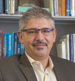
Eric Averett: The most challenging area is managing and mitigating impacts associated with demand reduction. Rather than mandating that individual landowners reduce demand, our district has pursued a path that we think gives individuals greater flexibility. The idea is that every acre will be assigned a water budget based on what the district can provide or considers sustainable. If a landowner uses more than that amount, it triggers a water charge. The district will use those funds to develop water supply programs or purchase land from willing sellers to retire it from production. Either way, this system doesn’t take anything away from landowners’ ability to manage their own water, it just gives them more options.

Another important area we’re looking at is water trading within our district’s boundaries. We’ve implemented a pilot study that empowers landowners to act as buyers or sellers in managing their water resources. We think water trading will be an essential tool to getting aquifers into balance and maximizing the value of the resource. For example, during a drought, a small grower with row crops may find greater value in fallowing a field and selling the water. At the same time, a grower who may be short of water and facing the loss of a permanent crop may enter the market as a buyer. If we don’t find a way to create these buy/sell opportunities, we strand the asset.

A third area we’re working on is creating individual groundwater bank accounts for landowners. We have a number of landowners who’ve committed to make their land available for recharge in exchange for a portion of the recharged water being credited to their account. Alternatively, some landowners have acquired a source of water and asked the district to use it for recharge on their behalf. Both types of programs were tested successfully in 2017, and we look forward to expanding the concept.   Ultimately, we’re looking at ways the district can assist landowners in becoming sustainable and mitigating SGMA impacts.

PPIC: How are you handling the issue of dry wells?

EA:  During the most recent drought, we experienced a number of wells that went dry. Kern County’s groundwater levels can be very dynamic, in part because of the groundwater banking projects within the region. These projects pump out large volumes of water during droughts, causing the water table to drop a lot and fairly quickly. We’ve developed a unique mitigation program in partnership with the banking projects. We utilize a groundwater model to evaluate the well in question. If it’s determined that the well’s failure was due to water level impacts from the banking projects, we mitigate the impacts. Within 24 hours of the well going dry they’re connected into a temporary water supply. To date, we’ve spent more than $1 million replacing and repairing wells, or connecting people with dry wells to local service providers. The proof of success is that not one landowner has pursued legal remedies, and all have been satisfied with the results. We think it’s a good template for others to try and may be a model going into the groundwater sustainability planning process.

PPIC: What’s the big lesson from your district’s efforts?

EA In all of these areas, our goal is to have the district be a resource for sustainability, not a regulator. Each landowner is unique: some have thousands of acres, and the impacts on them may not be as great as for someone with a small parcel. A lot of smaller landowners may be unable to manage the fixed costs that will arise from implementing SGMA. We wanted to address the diversity in our district and not disadvantage any one user.

We’re emphasizing approaches that let growers decide what’s best for them—whether it’s helping them put unused water into a market or compensating them for using their land for recharge. Everyone in the district will have to live with the water budget we come up with, but we want to provide as many tools and options to get to sustainability as we can.

Why We Need Working Floodplains

Floodplains are hard-working landscapes when they’re allowed to “act naturally.” But their flood-taming, habitat-feeding abilities are compromised when they’re paved over or constricted by levees. We talked with Josh Viers, a watershed scientist at UC Merced and a member of the PPIC Water Policy Center research network, about restoring floodplains.

PPIC: What happens when rivers are given more room to flood?
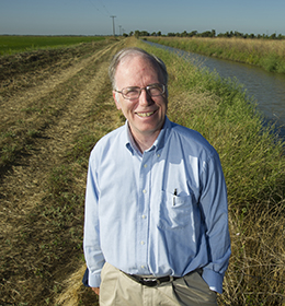
Josh Viers: River systems are highly dynamic—they’re always changing in time and space. As they rush from their headwaters, they break down mountains and transport a lot of sediment. By the time they reach the lowlands, they’ve started to deposit that sediment. It’s that dynamic between water and land that creates floodplains. Humans like to inhabit floodplains because of their rich soil and flat land. So we’ve engineered ways to protect people from floodwaters. But ecosystems evolved to have functions and processes that depend on floods. For example, flood flows are slower and warmer on floodplains. That creates good conditions for a lot of creatures―bugs, fishes, and birds, for example. When we cut off rivers from their floodplain, we’re cutting off these essential habitat functions.

We now recognize that giving rivers room to flood can have many beneficial outcomes. Dynamic river systems that are allowed to flood result in more complex habitats and more productive ecosystems. There’s a growing effort to reconnect floodplains to their rivers—for example, by setting back or breaching sections of levees. The most immediate benefit is a reduction in flood hazards downstream because you store some floodwater and some of the sediment that constricts channels on the floodplain. There are also ecosystem benefits. As more nutrient-rich sediments are deposited on the floodplain, they’re colonized by riparian plants, feeding whole communities of insects, birds, and other animals. Floodplains are also incubators for native fishes. Fishes on floodplains get much fatter than those that remain in the river, which can translate into better reproductive success. Floodwaters in floodplains can also recharge local groundwater supply, and they facilitate the long-term sequestration of carbon by burying plant matter with sediments deposited on the floodplain.

PPIC: Where is floodplain restoration underway?

JV: I’ve been part of a team of scientists looking at floodplain restoration on the Lower Cosumnes River near Sacramento. This river has no major dam on it so it has a relatively natural flow regime, including relatively frequent floods. We’ve studied how its floodplain responds to reconnection with flood waters after its levees were set back. And we’ve documented that setting back levees and allowing rivers to flood have multiple benefits for habitat and groundwater recharge while maintaining flood protection. The lessons from the Cosumnes are informing similar efforts in other locations—the Sacramento, San Joaquin, and Feather rivers are having some levees set back in strategic locations.

One of the more remarkable recent floodplain restoration projects is located at the confluence of the San Joaquin and Tuolumne rivers. Federal and state agencies have worked with landowners and conservation organizations to integrate flood protection and habitat creation through levee enhancements and the acquisition of key floodplain lands. The results have not only benefitted fish and bird populations, but also provided room for the rivers to behave more naturally in a location that has historically had large river meanders and complex features such as oxbows and sloughs―habitats that are now rare in the San Joaquin Valley.

PPIC: What’s slowing floodplain restoration in California?

JV: There are a number of obstacles. A big goal for these projects is to maintain or improve flood hazard reduction. So permitting processes can require fairly sophisticated studies that take time and money. They also have to undergo the same environmental review as any other construction project. And financing is a big hurdle. A few decades ago, floodplain restoration projects were fairly simple. Today, projects are bigger and more sophisticated, so costs have gone up. Also, projects can be hampered by urbanization, unwilling landowners, or poor conditions on the ground. That said, there are thousands of miles of levees and hundreds of miles of rivers, and many more places where we could do floodplain restoration.

Learn more
Read Floods in California (PPIC fact sheet)
Read “The High Cost of Fixing Levees” (PPIC Blog)
Visit the PPIC Water Policy Center flood resources page


Jay Lund Elected to National Academy of Engineering

Jay LundJay Lunddirector of the UC Davis Center for Watershed Sciences and adjunct fellow at the PPIC Water Policy Center―has been elected to the National Academy of Engineering (NAE).

Lund is one of ninety-nine new members in this year’s class. He was cited “for analysis of water and environmental policy issues leading to integrated water resources planning and management.”

Election to the academy is among the highest professional distinctions in engineering. It is one of four organizations that comprise the National Academies, established by Congress to advise the nation on a wide range of scientific and technical issues.

As a professor of civil and environmental engineering, Lund has led the development and application of large-scale modeling for California’s water supply, as well as modeling studies for managing floods, climate change adaptation, water marketing, water utility planning, and integrated water resources management.

“Jay has been an essential partner to the PPIC Water Policy Center. He is also one of the most important thinkers on California water issues today,” said Jeffrey Mount, a senior fellow at the center. “He thinks about problems from all angles—infrastructure, operations, economics, ecosystems, hazards—making him one of a kind. And he has guided numerous UC Davis graduate students who went on to become water leaders here in California and around the world.”

Lund said he’s thrilled at the honor. “I’d like to think this shows that my specialty of linking hydrologic and economic analysis for our big water challenges is valued—and also that the highest levels of the engineering profession value of engineers working with others, such as PPIC, to inform and aid with policy problems. That’s really gratifying,” said Lund.

The NAE is a nonprofit that provides engineering leadership in service to the nation. Its more than 2,000 peer-elected members and foreign associates are among the world’s most accomplished engineers. The new class of engineers will be formally inducted during a ceremony in Washington, DC, in September.

Congratulations to Jay Lund on this well-deserved honor.

Learn more

Read “Storing Water for Dry Days,” an interview with Jay Lund (PPIC Blog)

Lund has been involved in many of PPIC’s most important water reports. Here is a complete list of his PPIC water publications.