Paying for Water’s “Fiscal Orphans”

California’s water system is generally well funded and adequately maintained, but there are a few areas that lack a steady funding source. The most prominent of these “fiscal orphans” are safe drinking water for disadvantaged rural communities, flood management, stormwater management, and water for the environment. We talked to Dean Misczynski, an expert in infrastructure financing and an adjunct fellow with the PPIC Water Policy Center, about how to create a more reliable funding stream to address these problems.

PPIC: Are there better ways to pay for California’s underfunded “fiscal orphans”?

Dean Misczynski: Water is one of the easier things in government to pay for, because you can sell it. Local water fees and local taxes pay for most spending on water in California. State voter-approved general obligation bonds also play a pretty big role. But our thinking about how to use state bond acts developed sometime around the Civil War, and we could do a better job using bonds to fund 21st-century realities.

We currently use bond acts to raise the capital needed to build projects. But funding for the operation and maintenance costs of those projects is expected to come from somewhere else―or nowhere. No sensible business thinks this way; capital funding and operations and maintenance should be part of a unified financing plan. In addition to authorizing borrowing money for specified purposes, a state bond act could easily include ongoing expenses by appropriating money from the General Fund to pay for the operation and maintenance needed to make the project work. This approach would offer a more business-like, coherent financing plan and give voters a more honest look at what the undertaking would really cost.

To be clear, the operations and maintenance budget would not be part of the borrowing authorized by the bond act, because that would be an expensive way to pay for ongoing costs. But the funding would be earmarked and committed for the long term. And note that this doesn’t call for a new tax or fee; it just requires an ongoing commitment to use some General Fund dollars to cover the ongoing costs. In this way it’s similar to the bond itself—repayment comes from the General Fund, which ultimately comes from existing taxes.

PPIC: What types of issues would this approach be especially appropriate for?

DM: It’s best in situations where there aren’t good ways to cover operations and maintenance for projects funded by the bond. If we were to take this idea seriously, we’d want to do some careful thinking to identify the most legitimate uses of this new authority and to caution against using it for unnecessary or unwise purposes.

So, for example, a relatively well-off community getting a bond-funded project wouldn’t need state money for ongoing expenses. But for a water system in a very poor community, this type of funding mechanism could be very useful. There are a number of small, disadvantaged communities in the Central Valley that can’t afford to upgrade or maintain parts of their water system and that lack safe drinking water as a result. They might be good candidates.

These types of appropriations could also pay for ongoing expenses for projects that are important and have political support, but are easy targets for cuts during the state’s inevitable next recession. Two examples that come to mind are maintaining watershed areas, and data collection and analysis to improve water management.

This approach wouldn’t just be useful in the context of water—it could help with the transportation sector, low-income housing, and other statewide challenges. And it could be used as a model for local bond funding as well.

A Balancing Act for the Colorado River

The Colorado River―a critically important water supply for seven western states, including California―has been in drought for nearly two decades. We talked to Bonnie Colby, a professor of natural resource economics at the University of Arizona and a member of the PPIC Water Policy Center research network, about conditions in the basin and next steps for improving shared management of the river.

PPIC: What concerns you most about the river’s condition?
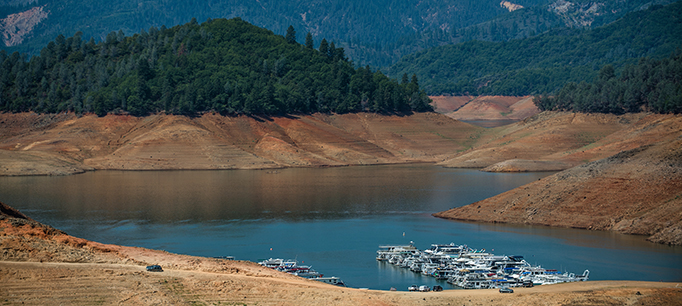
Bonnie Colby: We’re in a more difficult situation than in previous droughts because the major reservoirs—Powell and Mead—are so low. It’s unprecedented in my 35 years of working on water. Low reservoir levels increase the potential for conflict and make it harder to balance supply and demand. But our collective capacity to address these kinds of conflicts is growing as well.

Regionally, groundwater levels are falling dramatically from increased pumping during drought. That strategy brings hazards over time because river flows and groundwater are intricately connected, and overdrafting groundwater reduces water flowing into rivers. California is now working on groundwater sustainability, which is promising. Arizona has done a great job managing groundwater in heavily pumped areas (known as “active management areas”), but there are other places where groundwater use is not regulated to manage overdraft.

PPIC: What are your biggest concerns about current efforts to manage the river?

BC: There’s a fundamental conflict over who’s going to cut back on water use. Cities and environmental groups hope irrigated agriculture will use various proven strategies to free up more water for cities and the environment, giving up use of some of its water for fair payment. Some farmers are willing to cut back for a few years, but many are reluctant to do that indefinitely. No one can be sure whether this drought will extend for years or decades. The overall drying trend in the basin should alert us that the future will not merely repeat past drought patterns. Once we start reducing crop water use year after year in farming regions, it’s hard to maintain the agricultural economy and related infrastructure.

Delays in the “drought contingency plan” process are another concern. These plans lay out commitments by the states regarding specific steps to cut water use and help maintain reservoir levels during drought. Water conflict is a very hard puzzle to solve. It’s difficult to decide which groups will bear the economic pain and impact to their quality of life. If there are cutbacks for multiple years in a row, how drastically should cities be asked to reduce water use? How should we deal with water for golf courses, for farms? Until the states can finalize drought contingency plans, we can’t finalize a number of important policy agreements—for example, new agreements with Mexico over sharing the river’s waters.

PPIC: What are some positive things about the state of the basin?

BC: The state of Colorado has shown a lot of leadership in making arrangements with farmers to use less water without causing significant economic disruption. These on-farm collaborative arrangements are where the basin can make substantial progress. If we put farmers’ and irrigation district managers’ knowledge and experience to use through voluntary collaborative programs, we should be able to reduce farm water 5% while only seeing a 1% drop in farm income, with only minor effects on food and fiber production. Farmers won’t, and shouldn’t have to, do this at their own expense―compensation for farm income losses is necessary.

On another hopeful note, we’ve seen the conversation start to shift so that more people in the region see the river as a connected system, from its headwaters in Wyoming and Colorado to its estuary in Mexico’s Sea of Cortez. There’s more understanding about the importance of changes in snowpack patterns, long-term water scarcity, and other key issues. A better informed constituency is a very good thing for tackling basin-wide challenges.

How Much Water Is Available for Groundwater Recharge?

The wet winter of 2017 brought an opportunity to test groundwater recharge—the intentional spreading of water on fields to percolate into the aquifer—as a tool for restoring groundwater levels and helping basins comply with the Sustainable Groundwater Management Act (SGMA). This is especially important in the San Joaquin Valley, which has the biggest imbalance between groundwater pumping and replenishment in the state.

A key question for many valley water managers is how much water will be available for recharge in the long term. By law, only river flows in excess of what is required for environmental purposes and to supply existing water-right holders are available for recharge. A recent report by the PPIC Water Policy Center estimated how much water would be available in the San Joaquin Valley over the long term. Two earlier studies—one by two scientists at UC Davis and the other by the Department of Water Resources—estimated a maximum of about half a million acre-feet on average, which is about a quarter of the valley’s estimated deficit. The PPIC study updated these estimates in the context of current conditions and concluded that an average of more than a million acre-feet of San Joaquin River flows may be available.

There are two big challenges to getting more water into underground storage in the valley:

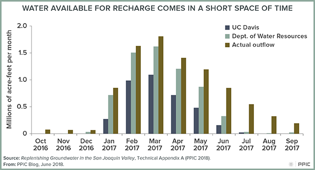
  • Most water for recharge becomes available during short periods. These periods usually coincide with floods, when recharge infrastructure—such as canals, pipelines, and recharge basins—is already working at full capacity. In 2017, for example, more than half of the available water would need to be diverted in February and March, with diversions above 30,000 acre-feet on most days (see figure). To put that into perspective, the California Aqueduct—the state’s largest conveyance system—has a maximum capacity of 26,000 acre-feet per day. While such daily volumes are lower than the overall volume of water moved in the valley during the summer irrigation season, seasonal floods are concentrated in relatively few areas where conveyance limits are likely to be a challenge.
  • Most of the available flows are in the northern half of the valley, while most of the overdrafted basins are in the drier south. This highlights the need to evaluate the capacity of large system-level water conveyance systems, such as the Friant-Kern Canal and the California Aqueduct, to move more water from north to south for recharge purposes.

The State Water Board—which oversees surface water rights—has the last word on this issue. Given the nature of California’s “flashy” river systems—in which very high flows develop rapidly during the winter and spring—the board will need to develop a simple, quick way to determine when river flows exceed water required for the environment and water-right holders.

We can’t count on groundwater recharge to singlehandedly end overdraft in the valley, but efforts to expand recharge in wet years will be helpful. The most pressing issues are to determine how much water is legally available and how best to put this water into the ground. Assessing the infrastructure needed for capturing flows during floods is an essential piece of this puzzle.

Blog figure: Water Available for Recharge Comes in a Short Space of Time


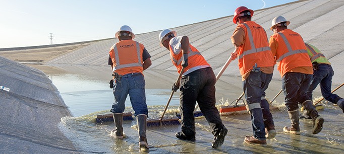
Image above courtesy of Jonathan Parker, Kern Water Bank Authority

Three Water Challenges for Almonds

California is a force of nature when it comes to almonds. The state’s farmers produce virtually the entire US almond crop and dominate the international market. As the market has grown, almonds have become California’s largest single crop—now accounting for about 12% of irrigated acreage, with more than 1.2 million acres harvested in 2016. Availability of water is clearly a major issue for the industry, since the trees must be irrigated throughout the long spring and summer dry season. At a May event on water issues organized by the Almond Board of California, I was asked for some thoughts on the water realities almond growers must grapple with in coming years. Here are three key takeaways.

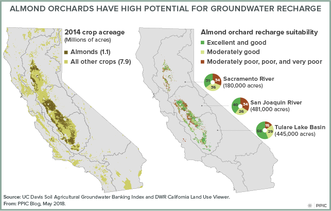
  • Growers in the San Joaquin Valley must address a long-term groundwater deficit. More than 80% of almond acreage is in the San Joaquin Valley (see map). Decades of unchecked pumping in the valley have resulted in a chronic groundwater deficit averaging nearly 2 million acre-feet per year—equivalent to about two Folsom reservoirs. Groundwater sustainability agencies must now devise plans to comply with the state’s 2014 groundwater law by bringing their water supply and use into balance over the next two decades. This means both augmenting supplies and reducing water use. Almond growers—along with others—need to be engaged in this process.
  • Augmenting local supplies can fill some of the gap––and almond growers can help. Up to a quarter of the San Joaquin Valley’s groundwater deficit could be eliminated by replenishing aquifers during high-flow events and wet winters like 2017. Spreading water on farmland is a cost-effective way to capture this water. Almond orchards are good candidates for such a process, given the suitability of much of the land for recharge (see map). Moreover, almond trees are dormant in winter and early spring, when extra water is most often available. Pilot projects and groundwater-recharge research are helping establish best practices and addressing ongoing questions among growers about the impact of winter flooding on almond crops. Almond growers also need to support other types of groundwater banking projects—such as recharge basins—that can help maximize available water supplies.
  • Managing demand will also be essential for reaching sustainability. Water use will need to fall to reduce the groundwater deficit. While this will pose some challenges, the good news is that farmers have been managing water demand for decades in this water-scarce region. Since the early 1980s, irrigated crop acreage in the San Joaquin Valley has hovered around 5 million acres, while the value of valley agriculture has roughly doubled (in today’s dollars). Farmers have responded to water scarcity by investing in crops and practices that generate more dollars per drop. The expansion of crops like almonds—and the corresponding decline in cotton and other field crops that bring in less revenue—reflects this shift. During the recent drought, farmers also used tools such as water trading and selective fallowing of less-productive lands. These same tools can help smooth the transition to balanced groundwater use, given the willingness of  water users who benefit most from using scarce supplies—for instance, those who need to keep orchards thriving during droughts—to compensate others who can use less.

Almonds are expected to remain a top crop in the state, and a leading source of farm revenues, for decades to come. But water stress will be an increasingly important factor for California’s almond growers and for the San Joaquin Valley more generally. The farm sector’s water challenges can’t be addressed farm by farm, or crop by crop. Cooperative approaches—including trading and groundwater recharge—will be essential to a smooth landing for the valley’s almond industry and the regional economy overall.

Expanding Groundwater Recharge in San Joaquin Valley Cities

The San Joaquin Valley is ground zero for groundwater management challenges. While agriculture is the region’s predominant water user, its cities are more likely to rely on groundwater as their primary source of water. For this reason, the urban sector will need to play a bigger role in the regional effort to balance groundwater use and replenishment.

Our recent research indicates that cities in the valley lag behind agricultural districts in the intentional recharge of groundwater. That’s primarily because most have limited access to two things necessary for storing more water underground: extra surface water and unpaved land on which to spread it so it can percolate into the ground. But some cities have had success with recharge activities. Here are three methods that can serve as models.

  • Partner with nearby agricultural districts. The city of Tulare relies entirely on groundwater for its potable water supply. It has an agreement with the Tulare Irrigation District (TID) for purchasing surface water, which is delivered to a recharge basin that the city co-owns with TID. The basin’s location allows for the recharged water to flow into the city’s pumping zone, even though the basin itself is not within city boundaries. The cities of Clovis and Fresno have similar recharge partnerships with the Fresno Irrigation District.
  • Partner with off-site groundwater banks. The city of Tracy relies on both surface and groundwater. In years when it doesn’t use its entire surface water allocation, it stores the unused portion in one of Kern County’s formal groundwater banks. Even though Tracy and the water bank are on opposite ends of the valley, a conveyance system allows for easy exchanges of water.
  • Recharge within city boundaries. The city of Bakersfield has rights to Kern River water. The city uses a direct recharge basin located within city boundaries to store some of its Kern River allotment.

Some cities engage in multiple recharging strategies. For example, both Tulare and Fresno operate flood control basins to maximize recharge, and Tracy pumps surplus water directly into a nearby aquifer through an “injection well.”

While these are all innovative models, most are still small-scale in terms of volumes recharged. Given the state’s mandate to balance groundwater use with replenishment by 2040, urban efforts will need to be scaled up as much as possible. Expansion will require better water accounting and basin planning. Cities can raise funds to partner with agricultural districts and undertake recharge projects, but they will need incentives and assurances that they will have access to the stored water.

Another critical step is to map and protect undeveloped urban land that is particularly appropriate for recharge. Cities should take steps to prevent the paving over of suitable soils, and encourage recharge on open space lands not only within city boundaries but also in areas into which they are likely to grow in the future—called their “spheres of influence.” As the figure below shows, suitable soils in these areas are extensive, especially in Kern and the eastern part of the valley.

It’s also important to remember that cities won’t be able to go it alone. In addition to partnerships with agricultural districts, broader local and regional cooperation will be critical for managing groundwater resources in the long run.

The Yuba Accord: A Model for Water Management

Last week a diverse group of stakeholders celebrated the tenth anniversary of the Lower Yuba River Accord—a historic agreement to improve conditions for the river’s endangered fishes, maintain water supplies for cities and farms, and reduce conflict over competing uses for water. Here at the PPIC Water Policy Center we frequently refer to the Yuba Accord as a model for modern water management in California. Here are three reasons why.

  1. Cooperation: The Yuba Accord happened because parties came together to develop an alternative plan in response to a state order calling for more water to support endangered salmon. By leveraging local management tools—including increased use of groundwater on farms during droughts—the accord has kept even more water in the river for fish than the state called for. This is a great example of how negotiated agreements can get broad buy-in and tap on-the-ground knowledge.
  2. Integration: Integrated water management gets better results by examining all the pieces of the water puzzle together to see how solutions to one problem might affect other areas. The Yuba Accord is a very effective example of this. The accord hinges on the flexibility achieved by managing surface water and groundwater as an integrated system to benefit salmon. But the augmented river flows provide additional benefits in Yuba County and beyond. The accord authorizes flows downstream of the Yuba to be traded to agricultural and urban communities farther south who face shortages during dry years. Moreover, the revenue generated by water trades has helped fund flood protection upgrades in Yuba County—an area facing high flood risk.
  3. Planning ahead: The accord demonstrates the advantages of planning for different hydrologic conditions. Careful work went into deciding how surface water and groundwater would be managed in wet and dry years. This meant that during the 2012–16 drought the Yuba was one of few watersheds in the state that was prepared to weather the extended dry conditions. California needs more such watershed-level plans for managing water for ecosystems before, during, and after droughts.

To be sure, Yuba County stakeholders started out with some advantages: in addition to relatively abundant water supplies, the county has a governance structure that makes integrated water management easier to implement. The Yuba County Water Agency (YCWA) is a county-wide special district whose board consists of county supervisors—local leaders for all county matters, not just for water. YCWA is responsible for both surface water delivery and flood management, and its boundaries overlap with the local groundwater basin. YCWA also had some very committed leaders who wanted to find a creative alternative to a protracted legal battle over flow regulations.

Even so, other California watersheds could adopt the accord’s focus on integrated, cooperative planning. One near-term opportunity lies in the implementation of the Sustainable Groundwater Management Act (SGMA), a state law that requires local water districts to bring their basins into balance but leaves it to the locals to decide how to achieve that goal. Another opportunity lies in improving conditions for fish and wildlife in Central Valley rivers as part of the update to the Water Quality Control Plan for the Bay–Delta. The State Water Board is proposing regulations to increase river flows, but is also inviting parties to propose alternatives that take a more holistic approach. This offers locals a chance to leverage the new groundwater management authorities under SGMA to integrate the management of groundwater and surface water. These kinds of pragmatic, consensus-based approaches can generate long-term solutions to some of the toughest challenges in California water.

Watch a short video about the accord.

Are California’s Cities Ready for the Next Drought?

California’s urban areas—where more than 90% of residents live—managed the last drought quite well. How well prepared are cities and suburbs to weather the next long dry spell? Here are two things to know about urban drought preparedness.

Are we backsliding too much on water conservation?

While it’s true that urban water use is not as low as it was at the height of the latest drought in 2015, it is still much lower than in 2013, before Californians were asked to significantly limit their water use. This winter, some media stories highlighted unfavorable month-to-month comparisons—for example, water use in December 2017 was about the same as in December 2013. But what’s lost in this message is that water use in California is normally much lower in winter months, when very little is going to outdoor landscaping. When we smooth out the seasonal differences, water use in 2017 was roughly 13% lower than in 2013—and it has stayed down across all regions of the state (see figure).

During droughts people save water in all kinds of ways, but especially by reducing landscape watering, which in normal years accounts for about half of all urban water use. During the latest drought this saved a lot of water, but it also entailed costs—gardens and trees died and urban landscapes suffered.

Another thing to remember is that the large reduction in urban water use in 2015 and early 2016 was the consequence of state-imposed mandatory rationing. It’s normal for water use to rebound somewhat when rationing is lifted. This also happened after other recent droughts. Generally, though, Californians have been reducing their water use for the past several decades.

What should cities be doing now to prepare for the next drought?

With California’s variable climate, it’s always prudent to be prepared, because the next drought can be just around the corner. Even though urban water utilities have done a good job preparing for past droughts, they can’t rest on their laurels. For example, as cities and suburbs become increasingly efficient with water over the long term, this affects their ability to tighten their belts during droughts. There’s less of a cushion and fewer easy steps that can be done quickly. Utilities will need to address this trade-off by ensuring that some portion of the long-term water savings is reserved in storage for times of drought emergency.

Urban utilities also need to be better fiscally prepared for times when they sell less water. This was a real weakness during the latest drought. The dilemma is that up to 80% of the costs of supplying water to businesses and households don’t change with the amount of water people buy. Utilities still have to maintain their systems, but most of their revenues are based on the number of gallons sold. When you start asking everyone to conserve, you can quickly end up in the red. We recommend that as soon as a utility knows it will have to ask for drought savings, it should inform its customers about how that could affect rates. Some communities have drought surcharges, which work well. The key is to have a plan, communicate in advance, and engage the public in understanding the issue of balancing revenues and costs.

Commentary: Replenishing Groundwater in the San Joaquin Valley

This commentary was published in the Sacramento Bee on April 18, 2018.

California’s biggest agricultural region also has the state’s biggest groundwater deficit, which has long-term consequences for the region’s economy and farming.

The San Joaquin Valley—where decades of unchecked pumping has depleted reserves, resulting in a long-term deficit of nearly 2 million acre-feet per year—has about a generation to bring its groundwater use into balance to comply with the state’s Sustainable Groundwater Management Act. Storing more water underground through “groundwater recharge” can help, reducing the deficit by about a quarter.

Read the full commentary on sacbee.com 

Image above courtesy of Jonathan Parker, Kern Water Bank Authority

3 Things to Know about California Droughts

The erratic weather in recent months—a dry winter followed by “atmospheric rivers” that packed a punch in March and April, capped by a poor report on the state’s snowpack—hasn’t exactly offered a clear picture for drought watchers. In fact, there is no universal definition of when a drought begins or ends. Here are three things about droughts that every Californian should know.

Rain, snow, and water in storage are the conditions that define a drought in California.

Technically speaking, a drought is simply having less precipitation than normal. But California’s climate is so variable—indeed, it’s the most variable in the nation—that our “normal” is often either very wet or very dry. We also have an annual, seasonal “drought” from late spring through early fall.

To cope with this variability, we’ve developed a massive storage system and conveyance networks to move water to places where it is scarce and demand is high. Thanks to this elaborate water system, California can face one or two much drier-than-normal years without major disruptions.

California’s mountain snowpack has historically provided “free” seasonal storage for meeting summer irrigation needs. About a third of the state’s annual water supply is stored as snow in the Sierra headwaters. Large reservoirs across the state capture melting snow and release it during our dry summers. Experts have recently begun referring to a new type of drought—“snow drought”—to define years when reduced overall precipitation coincides with unusually warm winters. The winter of 2015 was a good example, with the all-time lowest snowpack in recorded history. Unfortunately, this is becoming more frequent due to the warming climate, and it has big implications for water management because our current system isn’t designed for this shift from snow to rain.

Accounting for these conditions, most of California is not expected to be in a drought this year. Precipitation levels have been low—somewhere between “dry” and “below normal”—and the snowpack is about half of average, but the large reservoirs are still in good shape after the 2017 deluge.

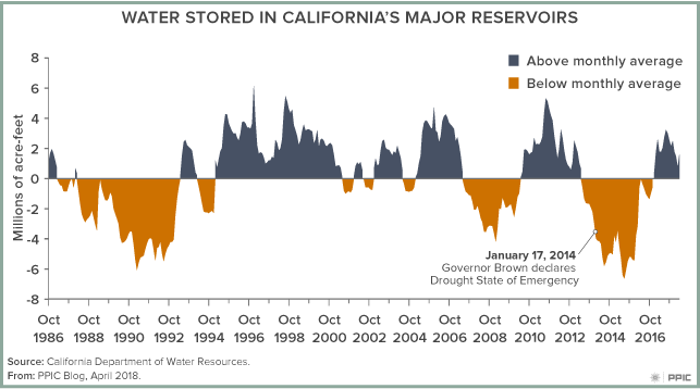
But this might change relatively quickly. As the figure shows, during successive dry years we rapidly draw down storage in reservoirs. By year two or three of a drought, reservoir releases are cut back and water scarcity becomes a problem, particularly in many agricultural regions. Groundwater helps reduce the impacts of drought, but it isn’t sufficient for extended droughts, and significant cutbacks in water use are required.

Drought vulnerability varies across the state.

California suffers a statewide drought only rarely, and the impacts of drought vary. Southern California is a relatively dry region, but it imports half of its water from Northern California and the Colorado River basin, both of which provide more reliable supplies. The central coast, which is not well connected to the statewide water system, relies much more on local precipitation and storage, which means it has a higher vulnerability to drought than other regions. In many areas, groundwater helps offset the loss of surface water during droughts. But long-term overreliance on groundwater—especially in the San Joaquin Valley—has led to negative effects, including dry wells, sinking lands, increased costs of groundwater pumping, and reduced supplies for future droughts.

Planning and preparing for drought can make a big difference. Our research has found that California’s cities and suburbs are the most drought-resilient areas of the state, thanks to significant local and regional investments in diversified water supplies.

Drought is not our only—or biggest—water problem.

Droughts worsen many of California’s water problems and heighten awareness of a number of other issues. But drought is not the underlying cause of critical, chronic problems facing California, such as difficulties accessing safe drinking water, our aquatic ecosystem crisis, or the unsustainable use of groundwater. Perhaps we put too much emphasis on drought―which is, after all, a natural feature of the state’s climate―and not enough on other critical issues.

Ecosystems Need Groundwater Too

Groundwater is a critical resource for most living things in California. But while human communities can increase groundwater pumping when surface supplies diminish during droughts, ecological systems often have no backup supply. We talked to Sandi Matsumoto, associate director of the Nature Conservancy’s California Water Program, about determining which ecosystems are particularly dependent on groundwater and what can be done to help them cope with dropping water levels.

PPIC: What are “groundwater-dependent ecosystems”?

Sandi Matsumoto: These are familiar places to everyone—wetlands, rivers, estuaries, springs, and associated plants and animals that rely on groundwater to meet some or all of their needs. They’re found in nearly all of the state’s groundwater basins and are often supported by surface waters, such as rivers and streams fed by rain or melting snow. Even deserts have them—where springs support desert oases, for example.

The Nature Conservancy has been working with California’s Departments of Water Resources and Fish and Wildlife to develop a comprehensive statewide map of vegetative indicators of groundwater-dependent ecosystems. Using plants as the prime indicators, we’ve mapped 2.2 million acres of groundwater-dependent ecosystems.

PPIC: How well do we understand the connections between groundwater and the ecosystems that depend on it?

SM: We’re definitely early in our understanding of this complex relationship. To fully understand it you’d have to get a hydrogeologist and an ecologist in the same room together—and you don’t see that pairing very often.

I like to think of rivers and streams as expressions of a healthy groundwater system. In California, rivers can flow well into summer months, long after the snowpack has melted. In areas with high groundwater levels, a lot of that river flow can come from groundwater. High levels of pumping can reverse this dynamic—when groundwater levels drop lower than the bottom of the river channel, water starts seeping into the aquifer. It’s called a “losing stream.”

Going forward, I think the Sustainable Groundwater Management Act (SGMA) will bring a much greater understanding of ecosystem conditions. By monitoring certain vegetation types we could improve our understanding even more. For example, we can look for signs of declining health in plants or changes in the number of acres of these “indicator plants.”

The trend has been a decline of groundwater-dependent ecosystems. The goal of SGMA is to stabilize things, but if groundwater sustainability agencies make a concerted effort, we may even be able to reverse the decline. For example, colleagues at the Nature Conservancy in Arizona are doing groundwater recharge projects near rivers, boosting their flow and improving conditions for riparian ecosystems. In California we’re trying to mimic seasonal wetlands by flooding farmland to support migratory birds. These kinds of projects help farmers while also providing habitat and even groundwater recharge benefits.

I also think that SGMA will force us to figure out what we care about and how to sustain those things. To get to groundwater sustainability we have to talk to each other, and experts will have to come out of their silos. If SGMA is done right, we’ll see hydrogeologists working with ecologists and other unlikely pairings. That’s what I’m most hopeful about.