The Yolo Bypass: It’s a Floodplain! It’s Farmland! It’s an Ecosystem!

This is part of a series on issues facing California’s rivers.

California’s biggest river—the Sacramento—needs a lot of room to spread in big water years. A floodplain project called the Yolo Bypass allows it to flood naturally, while also providing habitat for waterbirds, fish, and other aquatic species. We talked to Ted Sommer, lead scientist for the Department of Water Resources (DWR), about this versatile landscape.
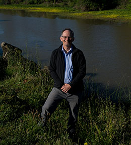
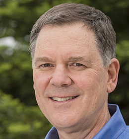
photo - Ted Sommer

PPIC: What is the Yolo Bypass, and what does it do?

Ted Sommer: It’s California’s primary floodplain. The Sacramento River drains a massive portion of the state, and the bypass gives it a large area—about 60,000 acres—to spill in high flood events. Then it drains safely back into the river and the Delta. You can see the bypass from highway 80 heading into Sacramento—it often looks like an inland sea in winter. It stayed flooded this year for months on end. If not for that floodplain a lot of people’s back yards would have been flooded in Sacramento. It’s a unique and effective part of the state’s flood management system.

The bypass also provides other benefits. Although its primary purpose is for flood management, it’s used extensively for agriculture. And it’s also managed heavily for wildlife. Its seasonal wetlands provide great bird habitat. And when flooded it serves as a nursery area for young fish in the Delta and good habitat for salmon migrating downriver to the bay. It’s a great example of balancing ecosystem benefits with other needs.

PPIC: What are some of the challenges in managing this landscape?

TS: One reason we started working on the bypass was the finding that a lot of key species do really well in wet years. So we started looking at this habitat that usually only gets flooded in wet years. Over 20 years of research on the bypass, we learned a lot about its role as a fish nursery.

In wet years this floodplain provides better habitat and more food for fish. But because it was designed as a floodway, the water shuts off quickly at the end of the wet season, and fish can get stranded or forced out of this habitat before they can get all the benefits from it.

We also found that the bypass is also a superhighway for many migrating adult fish—sturgeon, adult salmon, and others. The problem is that it is a dead-end in dry years. Even in wet years, as it starts to dry up, fish can get stranded as they move upstream in receding floodwaters.

Based on these areas of research, we’ve identified three priorities. The first is to improve fish passage. We’ve created a fish collection area in the bypass so we can help them get where they need to go in drier conditions. We also built a sophisticated fish ladder for fish migrating upstream during wetter years.

The second priority is improving connectivity between the river and its floodplain. A proposed notch in the top of the bypass would help extend the duration of flooding, giving baby fish more time in the nursery habitat. We hope to move forward with this project in the next several years.

The last improvement is to enable the floodplain to act as a foodbank beyond wet times. In recent years we’ve been working with water users, particularly rice farmers, to get pulses of water in summer and fall to move plankton downstream. Much of this water has already been used to grow rice and is returning to the system. Local farmers and water users have been great partners in this project.

PPIC: Is this model replicable elsewhere?

TS: Yes! Locally, the success of Yolo Bypass has helped fuel interest in restoring floodplain habitat in both the Sacramento and San Joaquin valleys. And it’s inspired people around the state and beyond to consider creating floodplains as part of their flood and ecosystem management strategies. People come from all over the world to visit the bypass. As the climate changes, such places can help manage flooding from extreme events while also providing many other beneficial uses.
A New Reality for Federal Flood Insurance

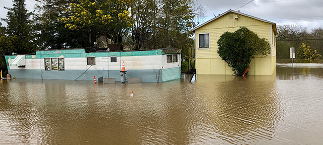
Flood damages have been rising around the country―most recently in the Midwest. The National Flood Insurance Program provides coverage to more than 5 million households and small businesses across the United States, including more than 229,000 in California. The program has been hard hit by payouts from major flood disasters in recent years and is heavily in debt. The Federal Emergency Management Agency (FEMA), which houses the program, has recently announced significant changes. We talked to Carolyn Kousky, a flood insurance expert at the Wharton Risk Center at the University of Pennsylvania and a member of the PPIC Water Policy Center’s research network, about the program.

PPIC: How is the national flood insurance program changing?

CAROLYN KOUSKY: FEMA is modernizing how it prices flood insurance policies, drawing on best practices in risk modeling. The changes are scheduled to roll out in October 2020. One big change is that new rates will be property-specific and based on factors like how close a property is to a river or its elevation. Higher-risk properties will have higher rates. Previously, everyone in a high-risk zone paid the same rates, regardless of the level of actual risk. This change should be easier to understand for residents, which is an important improvement. Economists have been calling for such an approach for a long time.

These changes will also mean that rates vary more smoothly across a community. FEMA flood maps designate so-called “100-year” floodplains. In the old system, if your house was just outside that line your rates dropped dramatically—it was like a cliff between rates. Neighbors might have differences of $1,000 or more, but of course the risk between neighboring houses was almost never that big. This new system should eliminate that cliff.

The new pricing won’t help low-income families afford insurance, so there will still be a need for an affordability program. But the new pricing will eliminate another inequity. The previous rates didn’t always take into account the value of the structure being insured. That meant that higher-value structures were paying less than they should, and lower-value ones were paying too much. So to the extent that the value of a house reflects income, poorer households were being penalized. This problem is now being fixed.

PPIC: The federal government has acknowledged that most of its flood maps don’t reflect rising risk, and now some communities have created stricter standards to help them prepare for floods in a changing climate. Will this new approach help the program prepare for climate change?

CK: In some ways, yes. One important thing the new pricing does is add flood risk from rainfall. Previously the program’s pricing largely only reflected risks from coastal storm surge and rivers overflowing their banks. Rainfall risk is increasing with climate change, so this is a very positive change in the program. We saw the damage that rainfall flooding can produce in an extreme way with Hurricane Harvey.

These annual insurance policies only price for next year’s risk―and this is how it should be. It wouldn’t make sense for property owners to have to pay today for risks 50 years down the road. So the rating changes are not about managing climate changes. But we do need to think about increasing climate risk when planning new development and infrastructure and making other longer-term investments.

PPIC: Do you think these changes will make the program fiscally sustainable for the long term?

CK: As I understand it, these changes are about making sure the prices better reflect current risks. Based on what FEMA has released so far, there’s no way to know how it will affect the program’s revenue.

This new pricing is definitely fairer and more reflective of risk. If Congress coupled that with forgiving the program’s existing debt—which is still in the tens of billions―the program could use this as a re-set on its fiscal sustainability. There is a bill in the House right now that would do this. But thinking about the long-term fiscal soundness of the program in the face of new urban development and a changing climate would likely require more than just rating changes.

That said, there are so many benefits to making these changes in the insurance program. It’s a great first step to modernizing the system.

Testimony: Upgrading California’s Water Grid to Meet 21st Century Needs

Ellen Hanak, director of the PPIC Water Policy Center, testified today (April 2, 2019) before the House Subcommittee on Water, Oceans, and Wildlife, at a hearing on the state of western water infrastructure and innovation. Here are her prepared remarks.

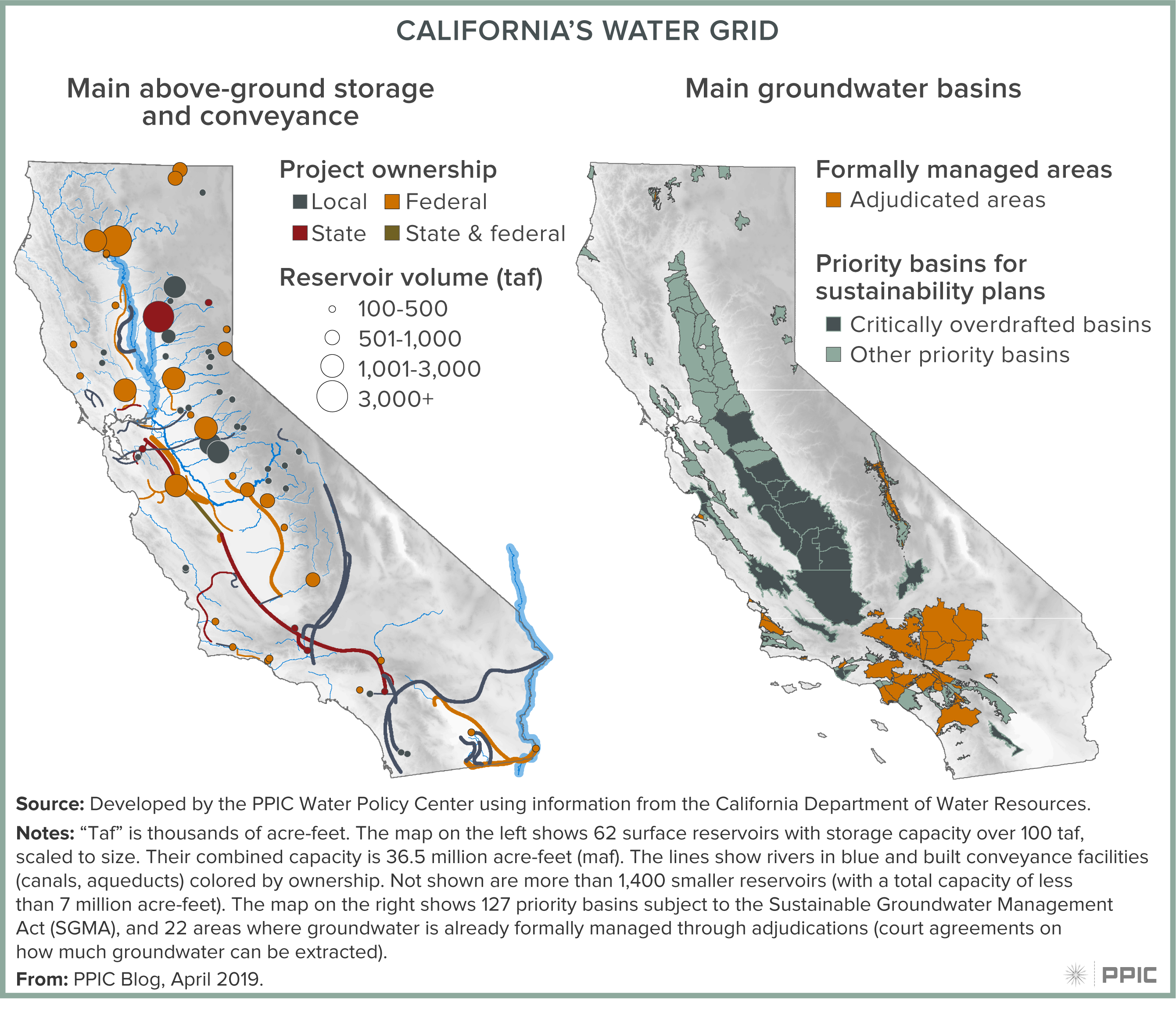
Most western states rely on water “grids”—networks of above- and below-ground water storage and conveyance systems—to manage their water supplies. California’s water grid is unusually extensive and connects most water use in the state. It is also complex, with different elements owned and managed by a wide array of local, state, and federal entities.

California’s water grid provides numerous services: it stores water, reduces flood risk, generates electricity, helps maintain downstream ecosystems, and provides recreation. But various factors are putting stress on this system. As the 2017 Oroville Dam crisis showed, the state’s above-ground infrastructure is aging—much of it is more than 50 years old. And in many areas, groundwater basins are being depleted, making wells go dry, raising pumping costs, harming ecosystems, and causing lands to sink and damage vital infrastructure. The changing climate is compounding these pressures.

figure - California's Water Grid

The PPIC Water Policy Center put together a team of experts in climate science, hydrology, ecology, engineering, economics, and law to review the weak points in California’s water system and recommend actions to build the system’s climate resilience. Our 2018 report Managing Drought in a Changing Climate found that five climate pressures—warming temperatures, shrinking snowpack, shorter and more intense wet seasons, more frequent extreme wet and dry years, and rising seas—will greatly challenge water management in coming decades.

Indeed, many of these effects are already occurring. Warmer, more intense droughts—such as the one California experienced from 2012–16—increase pressures to draw down groundwater reserves. Warmer, more intense storms add stress to surface reservoirs, making it harder to meet sometimes competing objectives of supplying water and protecting people and property from harmful floods.

California’s water grid is not prepared to handle these mounting pressures. Yet it is also the state’s most valuable asset for adapting to the changes in store. What’s needed is a more robust, better-integrated water grid. This will require investments to modernize not only the infrastructure, but also the way the system is managed. Here are some top priorities:

  • Enhancing groundwater storage. Groundwater is a vital drought reserve, and many California basins have considerable potential to affordably store more water. But the lack of active management—including tracking groundwater use—has been an obstacle to these investments. One very positive outcome of the latest drought was the enactment in 2014 of the Sustainable Groundwater Management Act, which requires local water users to develop and implement sustainability plans. The first plans are due in early 2020, and many will focus on new recharge efforts. In addition to expanding dedicated recharge ponds, some farmers and irrigation districts are experimenting with new methods, such as flooding suitable cropland during the winter months.
  • Repairing and upgrading dams, canals, and aqueducts. Addressing infrastructure weaknesses and gaps is essential for both flood protection and water supply. Expanding conveyance capacity will be key for getting water from winter and spring storms to where it’s needed for replenishing groundwater storage. This can also facilitate water trading—an important way to increase the flexibility of water supply and reduce the costs of water scarcity during droughts.
  • Rethinking infrastructure operations. California will be able to store more water if it manages surface and groundwater as a system to increase their combined potential. For instance, moving more water out of surface reservoirs and into aquifers in the fall can free up room in reservoirs to capture winter and spring storms. As another example, promising efforts are underway in some watersheds—including the Russian River, the American River, and the Santa Ana River—to update dam operations using advanced weather forecasting technology. More accurate forecasts can help managers decide whether they need to release water to protect downstream areas from flooding, transfer water to groundwater basins, or keep water in storage for later use.

There are many ways the federal government can help update the grid to meet 21st century needs in California and throughout the West. Here are a few priorities:

  • Assessing and improving system capacity. As owners and operators of major surface water infrastructure, federal agencies—especially the US Bureau of Reclamation and the Army Corps of Engineers—will be essential partners in assessing system capacity issues and the potential for new investments and operational changes to improve the grid’s performance and resilience.
  • Providing essential data. A variety of federal agencies—including the US Geological Survey and the National Oceanic and Atmospheric Administration—are key providers of data needed to better manage the grid under changing conditions. This includes essential metrics such as stream flows, weather forecasts, groundwater models, and space-based imagery to measure water use. These agencies also provide crucial biological data to help manage the grid sustainably. Some of these efforts have faced budget cuts in recent years, dampening their usefulness.
  • Supporting groundwater reform. To date, the federal government has been less engaged on the key issue of groundwater management—an underappreciated part of the grid whose importance will grow as the climate warms and water stored in the mountain snowpack diminishes. California is in the midst of a major, locally driven groundwater reform that will provide valuable lessons for improving the management of this vital resource across the western US and beyond. As owner and operator of the Central Valley Project, the US Bureau of Reclamation can support this effort by making it easier for its local water customers and others to recharge groundwater in suitable areas. As the regulator and manager of flood control systems throughout California, the Army Corps of Engineers can help local flood control agencies capture storm runoff and increase groundwater recharge. And as a major source of funding and technical assistance to farmers, USDA’s Natural Resource Conservation Service could help spur innovation by recognizing groundwater depletion as a resource concern, making it eligible for support.

California, like all western states, is facing major water management challenges as the climate warms and population grows. Weather extremes over the past decade have given us a glimpse of what the future holds. The best way to adapt to these changes is to modernize water grids. The federal government has been an essential partner in developing and operating these grids for more than 100 years. Given the challenges ahead, it is time to modernize this partnership, not just the grid itself.  This includes integrating federal support, operations, and technical expertise into all phases of water management, particularly groundwater.  From our many conversations here at PPIC with state and local water managers, California appears ready for an improved state-federal partnership.  I encourage members of this subcommittee to engage in finding ways to help modernize this relationship.

Rising Seas Bring Rising Water Management Challenges

Sea level rise—driven principally by melting continental ice and expansion of the oceans as they warm—is a significant threat for those living along the coast. Adapting to increases in coastal erosion and flooding—and managing the broad impacts of sea level rise on the state’s water systems—will be expensive and disruptive for millions of Californians.

A recent study by the US Geological Survey took a sobering look at future risks from rising seas. The authors describe how storm surge, very high tides (popularly known as king tides), and large waves during storms can amplify the effects of sea level rise. They simulated coastal erosion and flooding over the next two centuries and found there could be dramatic increases in damages during modest storms, and catastrophic flooding during rare, large storms. These impacts are projected to appear by the middle of the 21st century, at a scale likely to significantly affect the state’s economy.

Beyond costly efforts to protect against coastal erosion and ocean flooding, coastal areas will also need to manage increased inland flooding. Large storms can amplify the effect of rising seas by bringing greater storm surge, particularly if these coincide with king tides. Storm runoff flowing down coastal creeks will meet rising waters caused by storm surge and tides, exacerbating flooding. This issue is particularly acute in parts of the Bay Area (including much of Silicon Valley) and low-lying areas in Southern California. Major new efforts to manage runoff and protect existing homes and businesses will be needed.

Sea level rise will also affect water management in other ways. One area is wastewater treatment. Throughout coastal California and particularly in the San Francisco Bay Area, wastewater and stormwater treatment takes place in facilities that are currently at or near sea level. The Bay Area alone is home to 30 such facilities that are vulnerable to damage by rising seas and storms.

Water supply will also be affected. Many coastal aquifers will see increases in salinity as sea levels rise and storms push saltwater farther inland. But the most significant impact on supply is likely to be associated with changes in the Sacramento‒San Joaquin Delta.

The Delta lies at the head of the San Francisco Bay estuary and the confluence of the Sacramento and San Joaquin Rivers. More than 25 million Californians and 3 million acres of farmland rely on the Delta for a portion of their water supplies. These exports are managed by large state and federal projects that pump water from the southern Delta.

Sea level rise affects the Delta in two ways. First, to keep its waters fresh enough so that cities and farms can use it, a certain amount of fresh water has to flow out of the Delta and into the San Francisco Bay. If the outflow is insufficient—whether due to drought, reduced inflows from upstream water use, or high export pumping—tides push saltwater into the Delta, making its water unusable.

The second way sea level rise will affect the Delta concerns the 1,100 miles of levees that line its channels. Levees hold water back from Delta islands, whose lands are now well below sea level due to sinking soils. Failure of these levees—particularly in the western Delta—can lead to changes in the way tides circulate water in the Delta. These changes amplify the increases in salinity from sea level rise alone; together, they put additional pressure on water supplies.

Addressing the many effects of sea level rise on California water management requires extensive planning and costly investments in infrastructure. The US Geological Survey study shows that these impacts are not in some distant future, but are likely to become significant in just a few decades. The good news is that state and local officials are starting to work on this problem, which will take many years to address.

Connecting the Drops in Watershed Management

The interrelated nature of water issues has given rise to a management approach that integrates flood control, environmental water, and water supply. The Yuba Water Agency manages its watershed in this kind of coordinated manner. We talked to Curt Aikens, the agency’s general manager, about the lessons they’ve learned from this “integrated management” approach.

PPIC: Your agency manages the watershed for hydropower, water supply, flood control, and ecosystem health. What are some key elements to making it all work together?
Curt Aikens: I think the most critical elements to making this work for us are employing science and broad collaboration to sustainably manage all of the resources.

We try to make the most of every drop of water we touch—this infographic highlights how we do that. Our water provides recreation, carbon-free electricity, habitat for fish and wildlife, and a sustainable water supply for farmers and the 80% of our population that relies on groundwater for drinking water. In drought years, we transfer water to the state for use in the Central Valley and Southern California. We use the proceeds from those transfers and from hydropower sales to invest in reducing flood risk in Yuba County and other environmental, water supply, and public safety projects.

In managing this integrated system, we’re fortunate that our agency’s boundary fully contains our groundwater basins and most of the Yuba River watershed. The river flows right down the middle of the county.

We worked hard to get where we are today. In the 1990s we were involved in a contentious debate with conservation groups and state agencies over environmental flow requirements for the Lower Yuba River to support salmon and steelhead trout. To resolve the situation, we developed a collaborative, science-based settlement called the Yuba Accord. This agreement, which improved salmon and steelhead habitat, is a foundation for our success, because it helped us solve a number of problems collaboratively.

We try to ensure that everything we do has multiple benefits and comes from a strong collaborative effort. The Feather River Setback Levee is a great example of that. After Yuba County flooded in 1997, we commissioned a comprehensive flood study that presented half a dozen options to reduce future risk. Working with local conservation groups, we eventually settled on a program to set the levees back and strengthen them. This significantly lowered flood risk while producing ecological benefits for the river. The community gained a new, stronger levee, a significantly lower flood risk, and real ecological benefits.

PPIC: Is it harder to address multiple problems with one project?

CA: Today, it’s actually harder to implement a project with a single purpose. We live in a world with multiple interests, and we’ve found that multipurpose projects are a much better way to get things done. The Yuba River has more human impacts than most other rivers in the state. So we try to get ecosystem benefits out of most of our projects, whether it’s improving fishery habitat in our flood control work or strengthening water supply management through a project to build forest health.

Collaborative, science-based initiatives cost more and take more time upfront, but in the end you can get better results and more durable, sustainable solutions.

PPIC: Can this approach work well for water agencies that share a watershed with other entities or have other complicating factors in how they manage their system?

CA:  I think it absolutely can. There are many examples of multiple jurisdictions working together to resolve common water or natural-resource challenges. For example, the work being done on the voluntary settlement agreements in the Bay-Delta has brought together a really diverse group of conservation and water interests working toward an innovative solution. This approach is collaborative and science based. It also presents the opportunity for fish and wildlife habitat creation, new flows to support fish, and funding to help finance these activities.

Collaborative agreements, rather than a mandated regulatory approach, offer much greater promise for California’s environment and economic stability. This is exactly our experience with the Yuba Accord.  Continued leadership from Governor Newsom and his administration can help California create a sustainable solution for the entire Bay-Delta watershed.

How Climate Change Drives Disaster Cascades

California has had a devastating series of natural disasters recent years, prompting questions about the role of climate change in worsening fires, droughts, and floods. We talked to Amir AghaKouchak—an associate professor of civil and environmental engineering at UC Irvine―about how a warming climate is affecting natural hazards.

PPIC: Can you talk about how climate change is causing chains of extreme events?
Amir AghaKouchak: Climate warming can compound hazardous events. For example, this sequence of events led to devastating compound impacts in California: (1) severe drought in 2012‒16 weakened or killed many trees and vegetation; (2) record winter precipitation in 2017 caused epic growth of fine fuels like grass; (3) a warm, dry spring and summer dried out vegetation, leading to record-low moisture levels in this vegetation, (4) Diablo winds in Northern California and Santa Ana winds in Southern California set records for low humidity and sustained wind velocities; (5) record-setting fires occurred (e.g., the Thomas Fire in December 2017); and  (6) intense rainfall near Santa Barbara in January 2018 created the most deadly debris flows in history.

Cascading events are a special form of compound events. Sometimes the drivers involved in a cascading event are physically independent (e.g., a wildfire in summer and a rainfall event that winter), but they are linked through their impacts. The Thomas fire in Southern California didn’t cause the related mudslide. But the order of these events—they were about a month apart—had an extreme impact. Models show that a warming climate will bring more wildfires to California, which means a higher chance of future mudslides and debris flows.

We know, for example, that drought and heat waves are connected. It’s widely acknowledged that California’s climate is warming. But what’s striking is that our droughts appear to be warming much faster than the overall average. Heat waves often have atmospheric origins, but they can also be worsened by dry conditions. The way soil cools down is similar to what our bodies do—we sweat and are cooled by its evaporation. The land’s surface cools the same way. But when there’s little or no moisture for evaporation, the sun’s radiation warms the surface and intensifies heat waves. A hotter future will bring drier soil, which can lead to more intense heat waves.

PPIC: What can be done to better manage future extreme events?

AA: Historically, we have usually ignored the relationships among the variables used to assess risk. For example, US Geological Survey guidelines for flood risks in coastal areas do not consider the dynamics of the oceans. Sea level rise brings a greater chance of flooding in coastal areas due to higher tide and surge baselines. We need to develop methods that allow us to do more comprehensive risk analysis for floods, wildfires, mudslides, etc. On the science side, we need better methods to analyze the risks of related events. More public education and outreach about these types of events are also very important. Moderate rainfall may not worry you, but if it’s after a wildfire it could lead to extreme risks. We need to make sure people understand that moderate events can potentially lead to an extreme disaster cascade.

PPIC: What are some changes we should start making now to boost resilience for these “disaster cascades”?

AA: Policy change isn’t easy. But California is very progressive and has even formed a committee, which I’m a member of, to assess how climate change information can be used for improving engineering design and management of infrastructure. Our report identifies gaps and challenges, and offers nine major recommendations for making the state’s infrastructure “climate safe.” For example, we call for updating design and maintenance codes to enhance resilience. We also recommend funding collaborative efforts between state infrastructure agencies and climate scientists to develop tools for improving resilience.

Addressing these gaps won’t be easy. The good news is that the working group has had representation from all the major state agencies―including the Department of Water Resources, Caltrans, and the California Energy Commission. The agencies are interested in working together to improve resilience down the road. This is a very promising sign for the future.

Video: Water Priorities for California’s Next Governor

California’s many water challenges are complex, with many possible solutions and even more opinions about best approaches. How can a new governor forge a path forward in this critical area?

The PPIC Water Policy Center assembled a group of 16 experts this week for a half-day workshop in Sacramento to discuss how the new administration can promote water policies and practices that benefit the state’s people, economy, and environment. Lively discussions addressed three overarching topics: how local and state water policies intersect with California’s most pressing economic issues; innovations in policy, practice, and technology that offer better solutions for key water problems; and steps needed to adapt the state’s water systems to a changing climate.

Ellen Hanak, director of the PPIC Water Policy Center, summarized some major water challenges the new administration will face, including increased risks of drought and floods; poor water quality and drying wells in disadvantaged rural communities; and finding durable ways to pay for needed water system improvements. Leadership will be key to advancing solutions, she said.

“California has been a leader both nationally and internationally” on climate change mitigation and reducing emissions, Hanak said. “We think California has the potential to be a leader when it comes to climate adaptation as well.” She noted that water is a lynchpin issue for addressing the effects of a changing climate.

The first panel shed light on the links between water and the state’s leading economic challenges, from housing affordability to jobs. For example, growing water scarcity in the San Joaquin Valley—one of California’s fastest-growing areas―will affect plans to build new housing there. And regulation can complicate efforts to build affordable housing. Dan Dunmoyer of the California Building Industry Association noted that some water-related regulations—such as strict rules to prevent runoff from construction sites during the rainy season—can significantly increase building costs. Panelists agreed that better coordination could help open up many of these bottlenecks.

Denise Fairchild of Emerald Cities Collaborative highlighted the potential for job training programs in the water sector—which is grappling with the “silver tsunami” of an aging workforce—to create economic opportunities for low-income communities. “If we take this opportunity to rebuild California’s water infrastructure, it has great job generation potential” in communities affected by a historical lack of water sector investment.

The next panel looked at technical and policy-related innovations that can improve water management, such as weather forecasting tools that enable more nimble water management in dams—key to adapting to an increasingly volatile climate. Also, better information on agricultural water use can “empower communities to stop arguing about numbers and start working on solutions,” said Robyn Grimm of Environmental Defense.

The final panel explored opportunities to modernize the state’s water “grid”—its vast network of reservoirs, aquifers and conveyance systems—to make it more resilient in the face of five climate pressures: warming temperatures, shrinking snowpack, shorter and more intense wet seasons, more volatile precipitation, and rising seas. Improving water conveyance and reworking the current system would enable the state to “take advantage of bigger storms” linked to climate change by capturing their water for recharge, said Ashley Boren of Sustainable Conservation.

Each panel discussion included a quick round of “elevator pitch” advice for the governor-elect. Jennifer Pierre of the State Water Contractors captured the mood of the group with her pitch: “In water, flexibility is the name of the game—we need it for managing the existing grid, and for grid improvements. Don’t wait for the perfect plan; we’ll suffer every year that we delay.”

We invite you to watch the videos from this event and hope you find the discussions helpful:

Hurricanes Are Getting Worse. California Should Take Note

As Hurricane Florence ground its way through the Carolinas this past weekend, climate watchers couldn’t help but notice that the size and behavior of the storm have been eerily reminiscent of Hurricane Harvey, which devastated Houston last year. What made these two hurricanes so destructive was their slow pace and the fact that they were supercharged with moisture from bathtub-warm oceans. It’s a deadly combination that leads to epic, record-setting amounts of rainfall and unprecedented flooding, amplifying damage from the high winds and storm surge typically associated with hurricanes.

Once Florence leaves the Carolinas and the floods have receded, the nation will rally to clean up what will likely be of one of its top five most destructive hurricanes. Florence will add to this century’s staggering storm damage, caused by 22 hurricanes or tropical storms that led to more than $700 billion in damages in the United States (adjusted for inflation).

Is this part of a trend? Most certainly. The National Oceanic and Atmospheric Administration has a detailed analysis of billion-dollar US weather disasters since 1980. Clearly, weather impacts are getting much more expensive—and much more frequent.

What does this mean for California? First, like all other states in the nation, California relies upon the federal government to help with disaster preparedness, response, and recovery. The increase in the number of natural disasters and their growing costs affect the ability of federal agencies to respond. And the most important tool in mitigating flood risk—flood insurance—relies on an insolvent National Flood Insurance Program that will surely be hit hard by Florence.

Second, while it is tempting for Californians to write off Florence as a weather problem that affects the Gulf Coast and Atlantic states, this would be a mistake. We have our own hurricane-equivalents here, called atmospheric rivers. These can produce rainfall rates similar to those found in hurricanes, and they are responsible for most of our floods.

California is no stranger to extreme floods that rival hurricanes in terms of damages. The Great Flood of 1861‒62 affected the entire state and turned the Central Valley into a lake. If that same flood were to happen today, studies by the US Geological Survey suggest that more than $700 billion in damages would occur (equal to all the damages from all hurricanes nationwide in the past 18 years) and more than 1.5 million Californians would be displaced. Research by Daniel Swain, a climate scientist at UCLA, suggests that the risk of this scale of flooding is increasing as global warming intensifies. Indeed, his work has shown that the probability of a flood similar to the 1861‒62 flood occurring in California by mid-century is greater­ than the probability that it won’t.

Florence is a sobering hurricane that will likely be one of the worst in history. California would do well to heed some of its key lessons. As discussed in our recent report and highlighted by California’s Fourth Climate Assessment, flood risk is increasing due to climate warming. The 2017 crisis at Oroville Dam is an expensive reminder that California needs to upgrade its aging water management infrastructure. This will require finding new and innovative ways to fund flood management improvements.

California should also expand its efforts to steer new development away from high flood-risk areas through better land-use planning that incorporates increasing risk.

No matter how well California prepares, there will always be floods that overwhelm defenses, damage homes and businesses, and threaten lives. The state needs to continue to improve emergency preparations for floods and to encourage those who live in areas at risk of flooding to purchase insurance.

California has been a leader in reducing its contribution of greenhouse gases. But more work is needed to ensure its water supply and flood management systems are able to withstand a more volatile climate. California must act now to weather floods of the future.

Video: Managing Drought in a Changing Climate

As San Francisco began welcoming visitors arriving for this week’s Global Action Climate Summit, the PPIC Water Policy Center hosted an event on the impact of climate change on California’s water system.

The Monday event brought together a panel of experts to discuss reforms that could improve resilience and galvanize action to prepare for future droughts. The panelists were Maria Herrera, who works on water issues for Self-Help Enterprises and is a member of the California Water Commission; Felicia Marcus, chair of the State Water Board; Cannon Michael, president of Bowles Farming Company; and Tim Ramirez, a member of the Central Valley Flood Protection Board. The panel was moderated by Greg Dalton, founder and host of Climate One.

Ellen Hanak, director of the center, kicked off the evening with a summary of new research by PPIC on managing drought in a changing climate. After noting that California is already seeing changes from a warming climate, she said that “a lot of things we’re recommending are going to be very important and very useful as soon as we can do them.” She reviewed the report’s four main suggested areas of reform: plan ahead, modernize the water grid, update water allocation rules, and find the money to pay for these reforms. “It’s a plan that would be great for the next governor,” she said.

Dalton launched the panel discussion with a question about the need to modernize the state’s water grid—the network of above- and below-ground storage and conveyance systems that connects most water uses in the state. Ramirez said that the conveyance system needs updating because it is “totally insufficient for the precipitation we have now.” For example, the San Joaquin River system “was plumbed for snowmelt―very predictable, slow runoff―but that’s not what happens anymore.” He discussed the need for expanded floodplain capacity to help absorb floods.

Marcus said, “The answer is to maximize every drop—figuring out how every molecule of water … can be used over and over again and used for multiple things.” She said improved information and modernizing our thinking about infrastructure are steps toward achieving this goal.

Herrera noted that disadvantaged rural communities, which are most likely to face drought-related water shortages, find it difficult to engage in discussions about the water system. She called for ensuring that local communities are included in decision making about water grid upgrades, and added that they should have a say in “where to place storage, how water that is stored gets used and allocated, and for what benefits.”

Other topics of discussion included addressing growing wildfire risk; ensuring safe, reliable drinking water for the most vulnerable communities; advice for the next governor on managing climate volatility (Marcus: “the key is to pick up the baton and run with it.… [Water] is an issue on which leadership can make a difference on so many things”), and ways to reduce conflict over water.

Cannon Michael seconded the need for leadership to tackle climate change—and urged all Californians to heed that call. “We need to think about the California we have, what an amazing state this is, and lead from that. We’ve got to push past the voices that are trying to drag us apart, and work on solutions from the middle. We can solve any problem that we all put our minds together on.”

Remaking Flood Management to Support Salmon

California’s aquatic ecosystems and the species that depend on them are in trouble. Dramatic changes in water and land use over the past 150 years have transformed the state’s freshwater landscape, and the latest drought brought additional stress. We talked with Lewis Bair, general manager of Reclamation District No. 108, about where we need to go from here.

PPIC: What needs to change to reverse the crisis in the state’s aquatic ecosystems?

Lewis Bair: California’s water infrastructure was designed to manage floods and provide water for crops, and when it was built we didn’t really understand how this system might affect fish and other species. Now we know that the state’s flood management system cuts off rivers from their floodplains, which provide important habitat for aquatic creatures. We’re starving our ecosystem. We’ve removed 90% of the floodplains and lost 80% of the fish.

There used to be 25 salmon canneries on the Sacramento River. Between 1910 and 1930 the canneries lost 80% of their harvest. California hadn’t yet built its big reservoirs when this happened, but we had completely separated rivers from their floodplains, which were the main source of food for the fish. There are plenty of challenges for struggling species in California, but the floodplain issue is one we haven’t addressed and I think it could make a significant difference, especially for salmon.

Going forward, we need a fundamental change in our mindset, from the current focus on regulatory or mitigation approaches for habitat work to an emphasis on recovery. We need to get steady funding for recovery efforts and build the relationships required to be successful. That requires a lot of big changes—and also requires people to get out of their silos. We need better-coordinated science. And we need to review what we’ve learned and build on it.

PPIC: What does the condition of California’s salmon tell us about what is happening in aquatic ecosystems?

LB: Salmon are struggling, and it’s not a surprise. But there are things we can do to help. I’ve been fortunate enough to work on projects to restore parts of the floodplain to help salmon in the Sacramento Valley. There’s no question that floodplain restoration is the most important thing we can do for salmon right now. Our current flood management system tries to drain land quickly, but salmon and other creatures need the water to say in place awhile. The natural floodplain used to spread flood waters over a few weeks. Now the water comes and goes in just a few days. We’re working on a project that spreads water out and allows “fish food” to grow. You need 3‒4 weeks for that process to be really productive.

These floodplain efforts take place during winter, an off season for farming, which makes it a complementary practice to farming. The fish are essentially a third crop for these lands—rice is grown in summer, and the flooded rice fields support waterfowl in fall and winter.

PPIC: What’s needed to take recovery to the next level?

LB: We’re working with some environmental NGOs now to draft ideas on how to modernize the state’s water infrastructure to improve water for ecosystems. I truly believe that we have broad agreement on at least 90% of what is needed for our environment. Instead of arguing about the 10% where we don’t agree, we need to get the 90% done. The state may need something like a resources department with the authority and vision to oversee multiple agencies. The governor’s EcoRestore program for the Delta is one model for providing that leadership. Success will depend on having the locals and NGOs in key roles on the ground.

I’m very excited about the direction things are going right now. We have great NGO partners wanting to get past the perception that water users are the bad guys―now it’s all about how to move forward as partners.

Watch a panel discussion on partnerships for healthy ecosystems (with Lewis Bair)