Are Californians Prepared for the Next Natural Disaster?

Today marks the 30th anniversary of the Loma Prieta earthquake that shook Northern California. There’s a high probability that California will experience another major earthquake in the next 30 years. Given this threat—not to mention wildfires and floods—how worried are Californians about future disasters?

When asked about the potential impact of a disaster, six in ten adults are either very (28%) or somewhat (32%) worried that a household member will experience injury or property damage, or that a disaster will result in a major disruption of their household routine, according to PPIC’s latest statewide survey

Residents in Los Angeles (33%) and the Inland Empire (32%) are the most likely to be very worried, although majorities across regions are at least somewhat worried. Californians earning under $80,000 a year (35%) are twice as likely as those earning $80,000 or more (13%) to say they are very worried. Across racial/ethnic groups, Latinos (46%) are much more likely than African Americans (32%), Asian Americans (21%), and whites (16%) to be very worried.

figure - Los Angeles and Inland Empire Residents Are the Most Worried about a Natural Disaster

Despite high levels of concern, only three in ten Californians (29%) say they are very knowledgeable about the steps they can take to prepare for a disaster, while slightly more than half (54%) claim to be somewhat knowledgeable. Knowledge of disaster preparedness is similar across regions.

Yet differences emerge across demographic groups, with higher-income Californians (37% $80,000 or more) and homeowners (36%) more likely than lower-earning residents (25% under $80,000) and renters (24%) to say they are very knowledgeable.

How prepared are Californians for a natural disaster? Residents are more likely to have a disaster supplies kit (61%) than a definite disaster plan (50%). The share of Californians who report having a supplies kit or a definite plan is slightly higher than in 2014.

Residents in Los Angeles are the most likely to report having a supplies kit (65%) or a definite plan (53%). Across racial/ethnic groups, Asian Americans are the most likely to report having a supplies kit (65%) and African Americans are the most likely to have a definite plan (64%). Californians age 18 to 34 are less likely than older residents to have a supplies kit or a definite plan.

With the ever-present threat of earthquakes, wildfires, and flooding, Californians have to be prepared for an array of natural disasters. Stay tuned to the PPIC Statewide Survey as we track residents’ perceptions on this issue.

New Laws Help Prepare Communities for Wildfire

California has taken a number of steps over the past two years to reduce the pervasive threat of wildfires to the state’s communities and mountainous forests. Last year, Governor Brown focused on fostering more active management of headwater forests to improve their resilience to fire, drought, and pests. CalFire has begun spending the $1 billion allocated for forest health and fire prevention on projects across the state. These efforts are especially important to improve the health of headwater forests, which have become overly dense as a result of fire suppression.

This year, the legislature and Governor Newsom have shifted the focus to making communities more resilient to wildfire, including efforts to improve prevention, response, and mitigation. For example, the governor’s budget included nearly $1 billion in additional funding to bolster wildfire emergency response and mitigate threats to communities. The governor also signed several new laws to address community wildfire risks. Here are some highlights:

  • Help homeowners and communities become more fire resistant: New laws will increase the number of homes, businesses, and other properties that are resistant to damage from wildfires. Assembly Bill (AB) 38 creates a new program that will direct state and federal money to modify buildings and manage vegetation around properties. Senate Bill (SB) 190 requires the State Fire Marshal to develop model “defensible space” guidelines that local governments can use to enforce rules on reducing flammable vegetation around at-risk homes.
  • Improve wildfire emergency preparedness: Several bills will improve communication about impending wildfire threats and help communities prepare, including by setting up clean air centers. SB 209 creates a centralized state office for predicting and communicating wildfire weather threats to electric utilities, firefighters, and communities. SB 670 improves local emergency operations by requiring the Office of Emergency Services to share information about outages with 911 telephone services in threatened areas.
  • Manage flammable vegetation: Governor Newsom’s state-of-emergency proclamation in advance of this year’s fire season temporarily streamlined environmental review for CalFire fuel reduction projects in fire-prone communities. But CalFire will need to obtain environmental permits to continue that work under non-emergency conditions. SB 632 accelerates the approval of permits for fuel reduction to mitigate wildfire risk.
  • Increase oversight of electric utilities: A suite of new laws increases oversight of electric utilities. SB 70 requires utilities to justify decisions not to bury power lines, which can reduce wildfire risk. Vegetation management activities required by utilities’ annual wildfire mitigation plans will be subject to increased oversight by the California Public Utilities Commission under SB 247. And SB 167 requires those plans to also evaluate how power system shutdowns can affect vulnerable populations (such as people with medical conditions) and consider ways to mitigate these impacts. SB 560 requires utilities to provide advance warning about power shut-offs to entities that are essential to wildfire response, including public safety offices, health care facilities, and mobile telephone carriers.

Reducing wildfire risk in California’s many wildfire-prone landscapes is a multifaceted issue. Improving community safety and forest health are both key components of living with wildfire. Recent state policies have expanded the tools we can use to build resilience in our communities and forests. Going forward, much more can be done to improve our ability to live with wildfire.

Video: Californians and Their Government

As California’s 2020 Democratic presidential primary draws closer, Elizabeth Warren, Joe Biden, and Bernie Sanders lead the rest of the field by a wide margin. However, many voters say they would consider supporting a candidate other than their current choice. These and other key findings from PPIC’s latest statewide survey were outlined by Rachel Lawler in Sacramento last Thursday.

Likely voters identifying as registered Democrats or as Democratic-leaning independents support Elizabeth Warren (23%), Joe Biden (22%), and Bernie Sanders (21%) at levels well above Kamala Harris (8%) and Pete Buttigieg (6%). No other candidate is preferred by more than 3 percent, and 9 percent say they don’t know which candidate they prefer. More than half of voters who expressed a preference would consider supporting another candidate.

The survey asked about a $15 billion bond for school and college construction that has been approved by the legislature for the March 2020 ballot. It has the support of two in three adults—but only 54 percent of likely voters. This narrow margin of support coincides with concern about the state’s economic outlook. Fewer than half (41% adults, 37% likely voters) expect good times financially in California during the next 12 months.

A potential November 2020 ballot measure that would amend Proposition 13 to tax commercial properties at their current market rate and direct some of the new revenue to K–12 public schools is favored by 57 percent of adults. However, fewer than half (47%) of likely voters favor the measure, and this share is down somewhat from April 2019 (54%). A potential state bond measure to fund water infrastructure is favored by 68 percent of adults and 57 percent of likely voters.

Other survey highlights:

  • Californians are most likely to name homelessness (15% adults, 16% likely voters) and jobs and the economy (15% adults, 13% likely voters) as the top issue facing the state. Other issues named include housing costs, immigration, and the environment.
  • Most Californians view immigrants as a benefit to the state, and half are at least somewhat worried about someone they know being deported as a result of increased federal immigration enforcement.
  • Two in three Californians think the Supreme Court should not overturn Roe v. Wade; more than half think some states are making it too difficult to get an abortion.
  • Half of Californians say they have a disaster plan and six in ten have a disaster supplies kit. Six in ten are very (28%) or somewhat (32%) worried about personal injury, property damage, or a major disruption of their routine as the result of a disaster.


Managing Urban Water During Dry Times: The California Example

This article was posted on Meeting of the Minds on October 7, 2019.

California’s drought-prone climate, diverse and decentralized landscape of urban water suppliers, and complex water system make it something of a laboratory for testing ways to manage water scarcity. The state’s urban water suppliers have become particularly adept at managing drought, and this sector has become a leader in water use efficiency, recycling, supply diversification, and integrated management.

But the 2012–16 drought revealed that California’s urban areas must continue innovating to ensure water systems are resilient to climate change. Unusually severe, this drought included the driest four-year stretch in 120 years of record keeping. Record-high temperatures and record-low precipitation reduced water stored in mountain snowpack and intensified drought conditions in other ways—making it more like droughts of the future that are expected to result from a changing climate. The lessons learned from this research have relevance for other urban areas facing drought.

Read the full article on meetingoftheminds.org

How the USDA Helps California Farmers Steward Water and Land

The US Department of Agriculture (USDA) is the largest federal agency in charge of food and farm policy in the US. But the agency also has a lesser known role: it runs a large portfolio of programs to promote conservation of soils, water, and wildlife habitat on farms.

California gets on average $150 million a year from the USDA’s suite of resource stewardship programs. The programs are operated by two of the nineteen agencies within the USDA: the Farm Service Agency (FSA) and the Natural Resource Conservation Service (NRCS).

USDA’s conservation programs can be broadly grouped into three categories: (1) temporary land retirement programs, (2) longer-term or permanent “easement” programs to protect farmland, and (3) working land programs that focus on resource stewardship of lands in agricultural production. NRCS also provides technical assistance to support these efforts.

The temporary land retirement programs are underutilized in California. These programs pay landowners to take land out of production to implement conservation practices, such as planting cover crops to improve soil quality. These programs accounted for 3% of the USDA resource stewardship funding in California from 2012–17, versus 32% nationally. Low enrollment in these programs in California reflects a variety of factors, including low payments and high land values for irrigated cropland in the state.

Landowners who enroll in longer-term or permanent easement programs retain legal title but commit the land to a specific use—for instance, converting croplands to wetlands—or commit to prevent commercial development on farmland. These programs also account for a small share of the USDA stewardship portfolio. Nonetheless, USDA easements support important conservation efforts across the state. For instance, NRCS was a major partner in the restoration of Dos Rios Ranch, a project adjacent to the San Joaquin National Wildlife Refuge that converted agricultural lands to habitat and helped an endangered species, the riparian brush rabbit, make a comeback.

Working land programs are especially popular in California, accounting for almost 70% of USDA agricultural conservation funding in recent years. The majority of these funds have been used to install more efficient irrigation systems and replace old diesel engines on farms to protect air quality. Programs also support a variety of other activities, including managing manure on dairies to protect water quality or installing hedgerows to create habitat for pollinators on farms.

Generally speaking, the USDA conservation programs support conservation practices on a farm-by-farm basis. But to realize broader benefits, investments often need to be on a larger scale. The Regional Conservation Partnership Program (RCPP)—introduced in 2014—encourages landowners to join forces on resource concerns. To date, RCPP has funded 21 projects in California, including helping rice producers extend their watering season to support migratory birds and supporting development of a traditional land management plan by the Yurok Tribe.

There is considerable potential to use USDA’s stewardship programs in new ways to help address changes on the horizon for California’s agriculture. Across the state, farms face growing requirements to address water scarcity and quality problems. Ending the long-term overuse of groundwater is a huge challenge. In the San Joaquin Valley, closing the gap will likely involve idling some cropland. It will also require finding cost-effective ways to recharge groundwater basins.

To assist in these efforts, working lands programs could support on-farm recharge as well as management practices to prevent dust, pests, and weeds on fallowed lands. Temporary land retirement programs could fund multiple-benefit management of lands that are transitioning out of irrigation, supporting efforts to conserve water, recharge groundwater, improve soil health, and restore habitat.

The 2018 Farm Bill increased the USDA’s capacity to provide this help. Funding for the largest working lands program in the valley has been increased, and it is now available to support projects by local water management agencies as well as individual farmers. Funding has tripled for the innovative RCPP program, which leverages public and private dollars to tackle regional conservation challenges. And throughout the farm bill, conservation programs now cover soil health and carbon sequestration as targeted outcomes.

By working together with the USDA, the state’s farmers and their local and state partners could make better use of these programs and address new challenges at hand.

figure - USDA’s Working Lands Programs Are Popular in California, but Temporary Land Retirement Programs Are Underused

Water Policy Priorities for a Changing California

How will climate change affect California water management, and what steps should the state take to prepare for these changes? The PPIC Water Policy Center was asked by the Newsom administration to submit formal comments outlining key water policy priorities for the state—and ways to integrate actions across state agencies to implement these priorities. Our recommendations will inform the administration’s preparation of a water resilience portfolio. We address two key areas where the state can play a leading role—modernizing the water grid and protecting freshwater ecosystems.

California’s “water grid”—the network of reservoirs, aquifers, rivers, and water conveyance and flood control infrastructure that connects much of the state—was built for a climate that no longer exists. Yet it is the most important asset the state has for addressing changing conditions, both statewide and within regions. A modernized water grid, coupled with more flexible management, can reduce the cost of future droughts, improve how we manage flood risk, and help protect freshwater ecosystems. The state has made important advances in assessing and improving its water supply infrastructure, but it still lacks a comprehensive program to address storage, conveyance, and operational challenges in the next few decades.

California’s freshwater ecosystems present special challenges. The state’s native biodiversity continues to decline, despite decades of effort to improve conditions. Problems encountered during the 2012−16 drought—high water temperatures, low flows, insufficient cold water stored in reservoirs, and degraded habitat—will all likely worsen as droughts become more intense. Management of cold-water-dependent species—including salmon, trout, and some resident fishes such as Delta smelt—will continue to pose a significant challenge for water managers and regulators as conditions warm. Changing habitat conditions could make it impossible for some species to remain viable in their historic locations. And conflicts between the need to protect native species and land and water management activities are likely to increase. Here, too, some promising actions have been taken, but more needs to be done to prepare for coming changes.

Tackling these complex challenges with an integrated water resilience portfolio is a bold step, and one that has the potential to make California a leader in climate adaptation. You can read our recommendations to the administration here.

Managing a Non-Native Delta Ecosystem

The Sacramento–San Joaquin Delta has more non-native species than native ones, and its estuary is considered the most invaded in the world. We talked to Jim Cloern—an emeritus scientist with the US Geological Survey and an adjunct fellow at the PPIC Water Policy Center—about this challenge.

photo – Jim Cloern

PPIC: How have non-native species changed the Delta?

Jim Cloern: The plant and animal communities are very different than they were 50 years ago. There are more than 200 non-native species of animals and plants in the Bay and Delta; all were introduced by people, many in the last half century. Some of these introduced species are relatively low in abundance, but some have emerged as “keystone species.” That means they now play a prominent role in the ecosystem, either by changing processes like food production for fish or by reshaping biological communities.

Probably the best-known example is a non-native clam indigenous to Asia that was first discovered in Suisun Bay in 1986. It was most likely carried across the Pacific in the ballast water of a cargo ship. Prior to this there weren’t any native clams in that part of the estuary; with no competitors, its population exploded. The clams caused a major restructuring of biological communities with their fast consumption of phytoplankton—the food supply for zooplankton, which in turn are an essential food source for young fish. After the clams took off, production at the base of the food web decreased by a factor of five—a major shock to any ecosystem. This has been a contributing factor to the decline of native fish since the 1980s.

There are many other examples of non-native species that have disturbed the Delta. The clam is just the most striking because the changes happened so fast—and have persisted for more than three decades.

Many species were introduced intentionally—for example, the striped bass and large-mouth bass, both of which are now popular sport fisheries. Both prey upon smaller species of fish, including some we’re trying to protect, such as salmon. As juvenile Chinook salmon and steelhead migrate through the Delta to the ocean, they’re preyed upon by these introduced fish species.

Some non-native aquatic plants have caused significant harm to habitat. One is the water hyacinth. Anyone who boats in the Delta in summer runs into sloughs clogged with this floating water plant. It also blocks light below the surface, limiting phytoplankton production. Various efforts have been tried to control it, but they haven’t been effective. So the state now uses herbicides. We don’t know the environmental consequences of spraying these chemicals across the Delta.

Two more problematic non-native species are on the horizon: the freshwater quagga mussel and the nutria, a large rodent from South America. The quagga mussel was introduced in eastern waterways in the 19th century and has been making its way across the country. It’s now in Southern California. As with the clam, it outcompetes zooplankton for their phytoplankton food resource, disrupting food webs that support fish.

Nutria was farmed in the US for fur, and is a major problem in coastal Louisiana and the Chesapeake Bay. It poses a major risk to the Delta—not only for the ecological disturbance it creates, but also because its active burrowing threatens Delta levees already at risk from large storms.

PPIC: Describe how introduced species are affecting management of the Delta.

JC: We respond to ecological disturbance from introduced species with protective regulations and policies. For example, the state has begun a program to inspect boat hulls to make sure they don’t carry the mussel into new waterways. And the clam problem helped motivate California’s Marine Invasive Species Act, which directs commercial ships to either treat ballast water to kill species in it or discharge ballast water at sea. However, the state’s Marine Environmental Protection Division recently reported that the federal government intends to preempt state action on this issue.

But even with new policy efforts, the reality is that non-native species are making it harder to manage at-risk native species and ecosystems already challenged by harmful algal blooms, water diversions, habitat loss, and pollution from nitrogen and other nutrients.

PPIC: What should we do as next steps?

JC: Once a non-native species becomes established it’s very hard to eradicate. So we must try to prevent the introduction of new ones. And once they’ve been found, it’s critical to take urgent action to stop them from becoming established. A few decades ago we were caught off guard by the fast spread and large impacts of species introductions. We’ve learned how critical it is to act quickly, and California is now trying to actively prevent the spread of the quagga mussel, nutria, and other species.

The grand challenge of sustaining native species has turned out to be enormously difficult. That’s because their population losses are the result of many stressors—changing climate, habitat loss, pollution, non-native species, and water diversions. Success requires solutions built from a holistic, ecosystem-based perspective that considers ecological disturbance from introduced species in this broader context.

The Russian River: Managing at the Watershed Level

This is part of a series on issues facing California’s rivers.

Water managers across the state face new and more extreme challenges as the climate warms—from balancing the sometimes conflicting needs of urban, agricultural, and environmental water users to reducing risks from fires, floods, and droughts. We talked to Grant Davis, general manager of the Sonoma County Water Agency, about how his agency is approaching these challenges comprehensively, at the scale of the entire watershed.

photo - Grant Davis

PPIC: In your experience, what does it mean to manage at the watershed level?

Grant Davis: At its core, managing the Russian River watershed requires careful consideration of different land uses, stakeholders, water demands, environmental regulations, and ecosystem needs. We have to balance the competing needs of our 600,000 customers, a number of endangered species, recreational users, and a thriving farm community. In practice, we’ve changed our management considerably over the years. For example, we now intentionally release water from our two major reservoirs to improve estuary and fisheries management, while still meeting water supply needs.

In 2008, we began implementing what is known as a “biological opinion” designed to protect three endangered species—coho, Chinook and steelhead. An important element is restoring habitat on Dry Creek, a major tributary below our major drinking water reservoir. The idea is to slow water released from the reservoir to provide refuge for the fish. In the short run, it will likely make water deliveries harder, but it’s key to operating our system sustainably long term. When complete, we’ll have 6 miles of restored habitat out of a 14-mile stretch. It’s a multi-million-dollar effort—and a major undertaking in cooperation. Our agency has worked very closely with the regulating agencies and private landowners, who granted easements that enabled this restoration to occur.

PPIC: How do you use data sources to help you manage this watershed?

GD: We’re establishing information networks that bring multiple benefits. For example, we’re collaborating with the US Geological Survey on an integrated rainfall and stream gage network, which can help us evaluate whether storms might cause flash floods after fires. The rainfall data also helps with ecosystem management. In a changing climate, rainfall data is the primary input for understanding our watershed.

Since the Tubbs fire, we’ve begun working with more parties to leverage our respective data needs. For example, working with emergency responders, we’ve established a network of fire cameras that inform a text alert system. And working with PG&E, we’re looking at installing equipment to forecast atmospheric rivers and fire weather at the same weather stations.

It’s also critical that we use science to better understand atmospheric rivers, which will in turn allow us to better manage reservoirs as the climate warms. These large storms contribute to most flooding in California, and up to 95% of floods in our watershed. And the lack of atmospheric rivers leads to drought. We’re now working with the US Army Corps of Engineers, NOAA (the National Oceanic and Atmospheric Administration), the Scripps Institute of Oceanography, the Department of Water Resources, and other colleagues to study this phenomenon. Together, we’re developing a joint project that uses improved forecasting of atmospheric rivers to better manage water releases from reservoirs. We’ve built a coalition with other water agencies—including those in Orange County, Turlock, and Yuba—that are interested in exploring these same issues in their rivers. Data from the project will help us improve how we manage water supply, floods, and the environment.

PPIC: Talk about how the interaction between surface water and groundwater has affected Russian River water management.

GD: Our watershed is ground zero for efforts to understand the links between groundwater and surface water, and to better manage both together. In 2014, Mark West Creek was selected as one of five priority creeks as part of the California Water Action Plan. The creek goes through a depleted groundwater basin, which has affected its flows. The Department of Fish and Wildlife is now developing recommended flow levels to protect and restore the creek’s critical habitat. The project will also quantify human needs within the watershed.

In places like Mark West Creek, groundwater recharge can play a critical role in addressing the “timing divide” for maintaining freshwater fisheries—because the question is not always whether water is available, but when it’s available. A pilot project in the town of Sonoma will use Russian River surface water in wet winters to recharge the aquifer. We can then pump it when it’s needed in dry summer months for critical uses.

Thanks to Jay Jasperse and Carlos Diaz, both of the Sonoma County Water Agency, for their contributions to this article.

A California Dream: Less Plastic in the Ocean

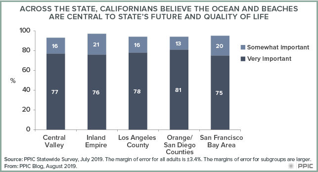
Friday is National Beach Day—an easy day to celebrate in California. The Golden State’s love of beaches is legendary, and as it happens it’s a legend backed by data. The latest PPIC environment survey found that three in four Californians (77%) say the condition of the ocean and beaches is very important to the state’s future economy and quality of life.

figure - Life

Californians are very concerned about a number of threats to their marine environment—including sea level rise, overfishing, and plastic pollution. Overwhelming majorities view plastic and marine debris as a big problem (72%) or somewhat of a problem (18%). Across age, education, income, and racial/ethnic groups, solid majorities say this is a big problem.

figure - Most Californians Say Plastic and Marine Debris along the Coast Closest to Them Are a Problem

The debris comes from diffuse sources. The California Coastal Commission reports that 80% of marine debris comes from land-based sources, such as litter that washes from land to the sea. Rain carries plastic litter of all sizes into the ocean through urban creeks and storm drains.

A growing concern is microplastics, debris that is too small to be caught by existing filters at wastewater treatment plants. This debris can come from personal care products rinsed down drains and synthetic fibers from laundered clothing. It can also come from larger pieces of plastic that end up in the ocean and break down. The most notorious example of this is the Great Pacific Garbage Patch, the eastern part of which is between California and Hawaii.

The problem is particularly acute in California. The San Francisco Estuary Institute reports that San Francisco Bay appears to have more microplastic pollution than other major water bodies in the US. A study by the Monterey Bay Aquarium Research Institute found that Monterey Bay also has high concentrations of microplastics. And scientists are now reporting that microplastics have been detected in Lake Tahoe for the first time, demonstrating the reach of the problem. Plastic is a problem across California’s waters.

Legislators are taking notice, with several bills currently aimed at tackling this issue. The goals are ambitious—for example, Senator Ben Allen and Assemblywomen Lorena Gonzales, both representing coastal areas of the state, have proposed bills that would slash single-use plastic waste in California by 75% by 2030.

While the outcome of such efforts remain to be seen, Californians’ concern about this problem—and their love of the ocean—is sure to drive momentum in the search for solutions.


Preparing California’s Rivers for a Changing Climate

This is part of a series on issues facing California’s rivers.

California’s rivers and streams have experienced enormous changes over the past 150 years, and a warming climate brings new challenges. We talked to Ted Grantham—a river scientist at UC Berkeley and a member of the PPIC Water Policy Center research network—about the state of the state’s rivers. Grantham was recently appointed as the first PPIC CalTrout Ecosystem Fellow. Thanks to the donors that helped us launch this program: Gary Arabian, the Morgan Family Foundation, Nick Graves, John Osterweis, and the Rosenberg Ach Foundation.

photo - Ted Grantham

PPIC: Talk about the changes affecting California’s rivers and streams.

Ted Grantham: California’s rivers and streams have experienced so much change since European settlement that they’re considered “novel ecosystems.” Gold mining and logging brought a massive amount of sediment into rivers. Riparian forests that lined Central Valley rivers and extensive wetlands on the valley floor have mostly been converted to farming. Non-native species have been introduced to most of California’s rivers, lakes, and estuaries, which prey upon or compete with native species. Urban rivers across the state have been channelized. And essentially every major river and stream in the state is impacted by a dam. Dams aren’t just barriers to migratory fish, they also alter downstream flows.

We’ve also prevented rivers from being able to move. Rivers are not static features; when given the opportunity, they will dynamically respond to changes in climate. This dynamism is inherent to how rivers work—it’s how habitat is created and maintained for many species. And it’s what makes these systems resilient over time.

Given all these fundamental changes, it’s remarkable that most of the state’s native fish species are still with us, although many are at risk of extinction.

PPIC: How are the state’s rivers expected to respond to climate change?

TG: The most direct change is increasing temperatures. Our rivers and streams will continue to heat up in a warming climate. Even if average precipitation stays the same, we’ll also experience more extremes, with both drought years and wet years more likely to occur. While increasing floods pose risks to some river ecosystems, it’s drought we’re most concerned about. Drought not only reduces the amount of water available for the environment, it also intensifies competition with other water users, making it harder to protect freshwater ecosystems.

Climate change is particularly problematic for cold-water fish such as salmon. In the short term, large dams have the potential to limit warming to some degree because they hold reserves of cold water. For example, Shasta Dam is managed to sustain salmon populations downstream through cold-water releases. But if water gets too warm over time, our ability to sustain cold-water reserves in the reservoir will decline. In the long term, redesigning dams to allow for fish passage or strategically removing dams will give salmon access to cold water in higher elevation streams.

PPIC: How can we prepare rivers for a changing climate?

TG: There are several promising management strategies that are gaining traction and could help build climate resilience in our rivers. Two important ones are securing environmental flows and restoring floodplains.

“Environmental flows” refers to the quantity, quality, and timing of water needed to maintain healthy rivers and ecosystem services that people rely on. In the past, little consideration was given to water needs of the environment. But that is changing and we’re seeing a growing effort to establish legally protected water allocations for environmental benefits. For example, I’m currently involved in the California Environmental Flows Framework, a program to support the development of environmental flow standards in rivers and streams throughout the state.

We’re also seeing more interest in multi-benefit approaches to floodplain management. Most of California’s rivers are disconnected from their floodplains, which have been converted to agriculture and urban uses. This has had huge impacts on fish populations and other species. As the likelihood of extreme floods increases with climate change, reconnecting floodplains is a cost-effective way to reduce flood risk. What’s exciting is that floodplain restoration can be compatible with agriculture and can also provide productive habitats. For example, the Yolo Bypass is primarily managed to protect Sacramento from flooding, but it also supports seasonal agriculture and habitat for birds and fish. Bringing water back to our floodplains can even help replenish groundwater, which is a critical water source in drought years.