Planning for a Drier Future in the Colorado River Basin

The Colorado River has experienced decades of over-allocation of its waters, making it harder to address the added challenges that climate change is bringing. The recently adopted Drought Contingency Plan (DCP) was an important step toward addressing the basin’s chronic water shortages, but more work is needed to prepare for a hotter, drier future. We talked to Doug Kenney—director of the Western Water Policy Program at the University of Colorado and a member of the PPIC Water Policy Center research network―about managing the basin for long-term water sustainability. Kenney organized a conference in June that covered these issues in depth.
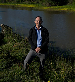
Photo of Doug KenneyPPIC: Talk about the basin’s over-allocation problem.

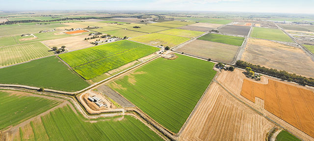
Doug Kenney: The current problem with the river’s water budget is in the lower basin. For much of this century, California, Arizona, Nevada, and Mexico have consistently pulled about 1.2 million acre-feet more water out of Lake Mead than enters it each year. That’s basically five years of water supply for Las Vegas. You can get away with that much overuse by drawing down reservoir storage—which is what we’ve been doing—but that’s not sustainable. So we need to accelerate efforts to scale back consumption. That’s what the DCP was designed to do—it’s mandated belt tightening.

In the upper basin states it’s a very different situation—water use in Colorado, New Mexico, Utah, and Wyoming is currently at a stable and reasonable level. But future use is expected to increase, while natural inflows are declining as the region continues to warm from climate change. The upper basin states can legally develop more water supplies, but the reality is that water isn’t likely to be reliably available. There’s a disconnect between how much water the upper basin states were promised and how much actually exists.

PPIC: What is needed to achieve sustainable management in the basin?

DK: The primary emphasis has to be on using less water. Given that most water in the basin is used for agriculture, that sector has the greatest potential to save water. Paying farmers to fallow some fields is probably the most appealing option. However, there are legal, financial, and cultural issues to deal with.

In most of the west, efforts to incentivize agricultural demand management have been pretty primitive—with the exception of Southern California, which has had major success trimming farm water use in the Imperial and Palo Verde water districts. Those programs aren’t perfect, but they are happening at a sufficiently large scale to make a significant contribution to addressing the regional water budget problem. In most other places in the basin, these types of programs are much smaller, and there’s a lot of skepticism about scaling these efforts up. The politics are very delicate, as these mechanisms would reallocate water from farms to cities. But you can’t ignore the math or the economics. Some sort of agricultural demand management will have to be a core element of any sustainable water use plan in the basin. The challenge is to do it in a way that is fair and protects the socioeconomic fabric of rural areas.

PPIC: What’s next for the basin’s water planning?

DK: The next steps are big ones. The operation of Powell and Mead is governed by interim guidelines that expire after 2026. Some key arrangements between Mexico and the US also expire then. The states are required to begin negotiating new rules to replace the expiring arrangements no later than 2020. This figures to be a really complex and very politically difficult negotiation, so there’s real interest in setting up the right process to get it done. That’s where many of us are focused right now—identifying the process that gives the negotiations the best chance for success.

PPIC: The DCP didn’t address ecological and health problems at California’s troubled Salton Sea. What’s next for the sea?

DK: At this point it’s about figuring out how to pay for what everyone knows has to be done. I’m convinced we’ve reached a turning point on the Salton Sea. There’s momentum within and outside of California to find a solution. It was disappointing that the DCP didn’t address the issues, but it wasn’t due to a lack of concern or effort—essentially, folks ran out of time. But I hear a consistent message from every sector and state: we need a solution for the sea. There’s an old maxim in this basin: anything is possible if all seven states can agree to it. I’m hopeful that this can apply to the Salton Sea crisis

Video: Californians and the Environment

In the wake of the devastating wildfires over the past few years, a record-high share of Californians are very concerned about wildfires becoming more severe as a result of global warming, and majorities support the newly established wildfire insurance fund. At a lunchtime briefing in Sacramento last Thursday, PPIC researcher Alyssa Dykman outlined these and other key findings from the latest statewide survey.

Eight in ten likely voters see environmental issues as very important in the 2020 presidential election. With the California presidential primary seven months away, Kamala Harris (19%), Elizabeth Warren (15%), Bernie Sanders (12%), and Joe Biden (11%) have the highest levels of support among Democratic and Democratic-leaning likely voters; a quarter of these voters are unsure about how they will vote.

More than half of Californians see the state’s leadership on climate change as very important, and majorities support state and federal efforts to address climate change—from renewable energy to land-use and transportation planning that reduces greenhouse gas emissions.

Other survey highlights:

  • Two in three Californians oppose allowing more oil drilling off the coast; seven in ten support offshore wind power and wave energy projects.
  • Majorities view pollution of drinking water as a more serious problem in low-income communities and support the state’s creation of a clean drinking water fund.
  • Many Californians value ocean and beach conditions and say plastics and marine debris are a big problem.
  • There are wide partisan differences on climate change and what the state should do about it.


Record-High Share of Californians Worried about Climate-Fueled Wildfires

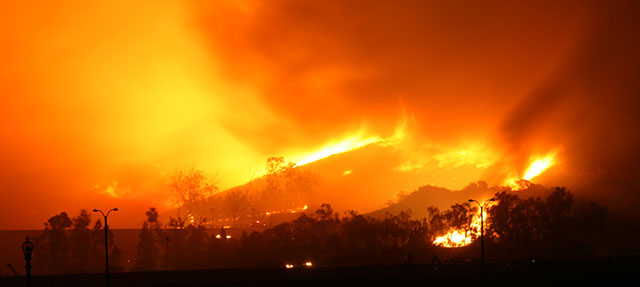
Two devastating wildfire seasons have put Californians on edge about future fire risk. Their concern is reflected in PPIC’s latest Californians and the Environment survey.

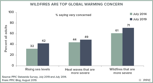
A record-high share of Californians (71%) report that they are concerned about wildfires becoming more severe as a result of global warming. This is an increase of 15 points since 2011 and 9 points since 2018. Concern over climate-fueled wildfires is significantly higher than concern about other potential global-warming impacts—this year it’s 29 points higher than concern over rising seas, and 22 points more than concern over worsening heat waves.

figure - Wildfires Are Top Global Warming Concern

About six in ten Californians (63%) say that global warming has contributed to recent wildfires, a share that has remained steady in recent years. Today, residents of Los Angeles (71%) and the San Francisco Bay Area (69%) are the most likely to hold this view.

Overwhelming majorities of Democrats (85%) and independents (70%), and about half of Republicans (45%), say they are very concerned about more-severe wildfires. Women (77%) are more likely than men (65%)—and young Californians (78% age 18 to 34) are more likely than older residents (66% age 55 and older)—to hold this view.

Back-to-back years of destructive wildfires brought attention to a lack of funding for post-fire recovery, especially following the Camp Fire, when PG&E faced record-high wildfire liabilities and filed for bankruptcy protection. Governor Newsom recently signed into law a $21 billion wildfire fund that will reimburse investor-owned utilities for payments they make to victims of wildfires caused by their equipment. The fund will be paid for evenly by utility investors and ratepayers.

PPIC’s survey found that the governor’s wildfire fund is favored by a majority of Californians (57%). Support is much higher in the San Francisco Bay Area (67%) than elsewhere. The plan is also popular among minority groups, with 73% of African Americans and 68% of Latinos in favor, compared to Asian Americans (55%) and whites (49%).

Post-fire recovery funding does not address the need to reduce wildfire risk factors, however. Our report Improving the Health of California’s Headwater Forests outlines reforms to ensure long-term forest health is a top priority for guiding agency rules, policies, and management practices in one of the more fire-prone areas of the state. It also describes ways to make the most of available funds for forest treatment needs.

The state has been taking steps in recent years to manage wildfire risks. In 2018 the legislature appropriated $1 billion for fire prevention and fuel reduction activities over five years. In April, the governor declared a state of emergency throughout the end of this fire season to spur proactive forest management, especially near high-risk communities.

This year’s state budget allocated significant financial resources to mitigate the funding gap in forest management as well. And the state just added 393 more firefighters to its ranks. Changes at the federal level in 2018 are also helping to reduce wildfire risk on federal lands. These changes give California a chance to increase the pace and scale of ongoing wildfire risk-reduction efforts and to prepare for a new wildfire reality.


The Yolo Bypass: It’s a Floodplain! It’s Farmland! It’s an Ecosystem!

This is part of a series on issues facing California’s rivers.

California’s biggest river—the Sacramento—needs a lot of room to spread in big water years. A floodplain project called the Yolo Bypass allows it to flood naturally, while also providing habitat for waterbirds, fish, and other aquatic species. We talked to Ted Sommer, lead scientist for the Department of Water Resources (DWR), about this versatile landscape.

photo - Ted Sommer

PPIC: What is the Yolo Bypass, and what does it do?

Ted Sommer: It’s California’s primary floodplain. The Sacramento River drains a massive portion of the state, and the bypass gives it a large area—about 60,000 acres—to spill in high flood events. Then it drains safely back into the river and the Delta. You can see the bypass from highway 80 heading into Sacramento—it often looks like an inland sea in winter. It stayed flooded this year for months on end. If not for that floodplain a lot of people’s back yards would have been flooded in Sacramento. It’s a unique and effective part of the state’s flood management system.

The bypass also provides other benefits. Although its primary purpose is for flood management, it’s used extensively for agriculture. And it’s also managed heavily for wildlife. Its seasonal wetlands provide great bird habitat. And when flooded it serves as a nursery area for young fish in the Delta and good habitat for salmon migrating downriver to the bay. It’s a great example of balancing ecosystem benefits with other needs.

PPIC: What are some of the challenges in managing this landscape?

TS: One reason we started working on the bypass was the finding that a lot of key species do really well in wet years. So we started looking at this habitat that usually only gets flooded in wet years. Over 20 years of research on the bypass, we learned a lot about its role as a fish nursery.

In wet years this floodplain provides better habitat and more food for fish. But because it was designed as a floodway, the water shuts off quickly at the end of the wet season, and fish can get stranded or forced out of this habitat before they can get all the benefits from it.

We also found that the bypass is also a superhighway for many migrating adult fish—sturgeon, adult salmon, and others. The problem is that it is a dead-end in dry years. Even in wet years, as it starts to dry up, fish can get stranded as they move upstream in receding floodwaters.

Based on these areas of research, we’ve identified three priorities. The first is to improve fish passage. We’ve created a fish collection area in the bypass so we can help them get where they need to go in drier conditions. We also built a sophisticated fish ladder for fish migrating upstream during wetter years.

The second priority is improving connectivity between the river and its floodplain. A proposed notch in the top of the bypass would help extend the duration of flooding, giving baby fish more time in the nursery habitat. We hope to move forward with this project in the next several years.

The last improvement is to enable the floodplain to act as a foodbank beyond wet times. In recent years we’ve been working with water users, particularly rice farmers, to get pulses of water in summer and fall to move plankton downstream. Much of this water has already been used to grow rice and is returning to the system. Local farmers and water users have been great partners in this project.

PPIC: Is this model replicable elsewhere?

TS: Yes! Locally, the success of Yolo Bypass has helped fuel interest in restoring floodplain habitat in both the Sacramento and San Joaquin valleys. And it’s inspired people around the state and beyond to consider creating floodplains as part of their flood and ecosystem management strategies. People come from all over the world to visit the bypass. As the climate changes, such places can help manage flooding from extreme events while also providing many other beneficial uses.

The State of Wildfire Risk Reduction in California

After a few horrific years of extreme wildfires, California has been taking steps to reduce future risks with new programs, increased funding, and new policy efforts. We talked to Van Butsic—a land use scientist at UC Berkeley and an adjunct fellow at the PPIC Water Policy Center—about these efforts.

PPIC: Is California doing enough to manage its forests and reduce wildfire risk?

Van Butsic: Probably not, but it’s definitely doing a lot more than it was five years ago. The state has made a substantial effort to deal with the issues around wildfires—just not yet at the scale needed to get big results.

The state has been pretty active in the past year on addressing some of the shortcomings of federal forest management—the federal government is the biggest landowner of California’s headwater forests. One interesting thing the state is doing is using some funding—about $200 million a year—from the Greenhouse Gas Reduction Fund on fuel reduction projects. These projects are managed by multiple stakeholders, and many are on federal lands.

PPIC: The Newsom administration has taken additional steps to address wildfire risk. Where do you think they’re on the right track? What elements are still needed?

VB: They’re doing a better job in realizing we need to have more hands-on management. Governor Newsom issued an emergency order that reduced environmental review for a handful of fuel reduction projects, which means they can take place a little quicker and address fire risk this season. And they’re investing a bit more money in fire suppression.

I’d like to see more work in building community wildfire resilience across the state. We need stronger policies that start at the house and work outward—to ensure that homes are hardened against wildfires (for example, with more fire-resistant roofing materials) and have defensible space around them. Most importantly, we need a systematic plan to prevent further expansion of communities into areas where catastrophic wildfires are a risk.

PPIC: Talk about new funding tools that can help improve forest health.

VB: One approach being considered depends on the state’s willingness to pay for measures to reduce the risk of big wildfires as part of its effort to reduce carbon emissions. The idea would be to use the carbon market to fund forest management practices.

A second area where we’re seeing bit of action is on water issues. Forest thinning can in some cases lead to more water in streams. We’ve seen a few projects that fund forest management activities in hopes of getting more water as a benefit. The big question is, how much more water will you get by thinning forests? It’s a pretty complex question that has to do with existing vegetation and the elevation of the land. It’s a bit of a challenge to find the sweet spot—the science isn’t settled yet on where forest management can increase water yield.

PPIC: What about fire risk outside the headwaters?

California has many forest types and landscapes that are prone to wildfire. Many of our larger wildfires have been in the Sierra headwater forests, which are currently too dense—they’re primed for large, high severity wildfires, and we need to address this problem.

But many of the homes impacted by wildfires in the past decade are not in traditional headwater forest areas. Managing these risks is really different from managing forests—it requires different policies and funding. Building codes are one way, but they’re mostly devised at the local level and aren’t uniform—some municipalities have better fire-resistance standards. The state does fire-severity-zone mapping, but not a lot of local governments are paying attention to that. I’m not sure what the state’s role should be in that regard. I’ve done some work in France, where the federal government says where you can and can’t develop in areas prone to wildfire, and as a result they have far fewer homes in at-risk areas. I’m not sure if that’s a tradeoff Californians would be willing to make.

An Opportunity to Restore Fish Abundance on the Eel River

This is part of a series on issues facing California’s rivers.

The Eel River—once home to the state’s third-largest salmon and steelhead runs, all of which are now listed as threatened―may see the return of healthy fisheries in coming years. A unique opportunity to remove a dam that blocks fish from reaching spawning habitat has arisen. We talked to Curtis Knight, executive director of CalTrout, about the situation.

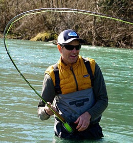
photo - Curtis Knight

PPIC:  Why is the Eel River important for California fisheries?

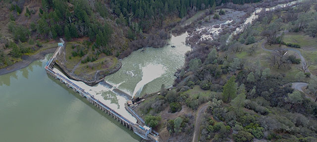
Curtis Knight: This a complex system that involves two of the biggest coastal watersheds in the state—the Russian River and the Eel River. The Eel presents the best opportunity to restore historic fish abundance in California. The river is blocked by two aging dams—Cape Horn Dam, which diverts water from the Eel to the Russian River for hydropower and other uses and has limited fish passage, and Scott Dam, which has no fish passage and blocks important upper watershed fish habitat. Scott Dam is owned by PG&E, which is attempting to divest itself of the project. This presents an opportunity to reestablish fish into the upper Eel basin.

On the Russian River side, irrigators and others benefit from the water diversions. This water is used to grow crops like wine grapes and keep the river flowing for endangered species and recreation.

On the Eel River side, it’s all about wild fish. Getting fish into the upper watershed above the dam is a top priority for local tribes, NGOs, and others. We did an assessment with Humboldt State University that found more than 150 miles of quality habitat for salmon and steelhead above Scott Dam. This stretch includes high elevation habitat that is rare in the coastal range. Getting salmon and steelhead into this cold-water region will be increasingly important for these fish in a warming climate.

Congressman Jared Huffman has formed a committee to develop recommendations as part of the Federal Energy Regulatory Commission’s (FERC) dam relicensing process for this project. The committee’s goals are to improve fish passage and habitat on the Eel to support naturally reproducing and harvestable native fish populations and to minimize impacts to water supply reliability, fisheries, water quality, and recreation in both basins.

The committee is looking at various fish passage alternatives, but Scott Dam is tall, which makes fish ladders—step-like pools to enable fish to cross the dam—really expensive and not very effective. Trucking fish around the dam, as is done in some watersheds, is also being explored, but in my opinion is not sustainable and won’t lead to fish abundance. Removing Scott Dam would clearly be the best way to restore fish abundance in the Eel River.

PPIC: Is there concern about losing both the water and the energy?

CK: The project doesn’t produce much power. The real value is the water. PG&E is walking away from the project in part because they lose roughly $5 million per year operating it.

On July 1, Humboldt County, Sonoma Water, the Mendocino Inland Water and Power Commission, and California Trout applied to take over the dam relicensing process from PG&E. The purpose is to work toward the two-basin solution and ensure the future of the project is determined locally.

Congressman Huffman’s committee will play a central role in determining what the project will ultimately look like. But one idea is to remove Scott Dam while still diverting water to the Russian River during the winter via Cape Horn Dam. Fish passage would have to be improved at Cape Horn and there are Russian River interests that would need to be met. The loss of water storage from Scott Dam can potentially be offset by storing Eel River water in Lake Mendocino. This would certainly be a good scenario for Eel River fish, but there are still some challenges to overcome.

So while there is still a long way to go, we are confident we will come up with a locally derived solution that meets the needs of fish and people in both the Russian and Eel Rivers.

Photo credit: Mike Wier, California Trout

Got Surface Water? Groundwater-Only Lands in the San Joaquin Valley

The San Joaquin Valley—California’s largest agricultural region—has the largest groundwater deficit in the state. However, water scarcity is not experienced equally across the valley. Some areas receive abundant surface water to support cropland irrigation and drinking water supplies. Most others supplement their use with groundwater. Still others have no surface water access and depend entirely on groundwater. Water users in these groundwater-only areas are particularly vulnerable to pumping restrictions under the Sustainable Groundwater Management Act (SGMA)—the state-mandated effort to balance groundwater basins.

The map below gives a broad view of where the groundwater-only agricultural lands are located in the San Joaquin Valley. These areas are present in each basin; they include irrigated cropland (shown in red on the map) as well as rangeland and other open space (shown in gold).

figure - Nearly 20% of Irrigated Cropland in the San Joaquin Valley Relies Entirely on Groundwater

We estimate that nearly 20%—or 840,000 acres—of irrigated cropland in the valley has no access to surface water. Crops are similar in groundwater-only lands and lands that have at least some access to surface water: more than half are planted with permanent fruit and nut crops. These crops provide higher revenues and employment than most annual crops. With groundwater cuts looming and no other water supply to fall back on, groundwater-only areas are on the front line of the effort to bring basins into balance. Inflexible approaches to managing this transition could result in unnecessarily large, undesirable reductions in high-value crop acreage, regional employment, and GDP.

Cooperative approaches to water management can give flexibility to groundwater-only areas and lessen the regional economic burden of reducing groundwater use. Facilitating local surface and groundwater trading would allow farmers who need more water for their orchards and other high-revenue crops to compensate other farmers for reducing their water use. Expanding surface water trading more broadly across the valley could bring down costs further and offer even more flexibility. And smart regional investments in new water supplies—particularly to capture more runoff from big storms and increase groundwater recharge—could offset some of the water use cutbacks expected in groundwater-only areas.

Cooperation will also be important to ensure adequate water supplies are available for the valley’s growing cities and small towns—most of which also rely heavily, if not entirely, on groundwater. Recharge partnerships that benefit communities are one promising way to do this.

Water conditions in San Joaquin Valley basins vary, from the size of a basin’s groundwater overdraft to the availability of surface water in the local supply mix. These variable conditions call for cooperation between those with access to surface water and those without. This will make it possible to lessen the costs of implementing sustainable groundwater management, a transition that will benefit the valley over the long run.

The LA River and the Trade-Offs of Water Recycling

This is part of a series on issues facing California’s rivers.

After a very wet winter, California has been declared drought free. But planning for future water shortages has continued. In Los Angeles, Mayor Eric Garcetti recently announced a goal of 100% wastewater recycling by 2035 to help make city supplies drought proof.

While recycling wastewater helps cities adapt to a changing climate and prepare for droughts, it can have unintended consequences for local watersheds. In some cases, the growing use of recycled water could minimize or even eliminate flows from wastewater treatment plants into local rivers and streams and reduce ecological and recreational benefits. The Los Angeles River exemplifies this kind of trade-off: expanded water recycling will reduce the amount of treated wastewater flowing into this increasingly revitalized urban waterway.

The lower stretch of the river, which was converted into a concrete flood channel in the mid-1900s, is changing. Concrete has been removed from large stretches of the river and public parks and bike paths have been built along its banks, encouraging recreational use and increasing public interest in the river’s restoration. The river was declared a navigable water in 2010 and opened to kayaking the following year. It provides a vital refuge to a variety of riparian species that lost most of their habitat to channelization and urban development.

Last year, researchers from the Southern California Coastal Water Research Project (SCCWRP) launched a study to document the effects of reductions of treated wastewater on vulnerable species and habitats along the highly urbanized, 45-mile stretch of the lower river, as well as on recreational uses of the river. One of the project’s goals is to determine how these impacts could be offset by investments in river restoration and upstream mitigation projects.

The SCCWRP researchers plan to develop recommended seasonal flow targets for each section of the LA River. They will consider the balance between protecting the river’s ecological and recreational uses and local agencies’ desire to capture, divert, and recycle more water in the watershed. The study will also help inform a number of planning efforts, including One Water LA and the LA River Revitalization Master Plan.

Eric Stein, principal scientist with SCCWRP, emphasized that the project’s success is dependent on its collaborative nature. “We are bringing together agencies, municipalities, nonprofit organizations, and community groups to help explore alternative future scenarios and find innovative ways to balance potentially competing demands for water in the LA River,” he said.

The LA River watershed is only one example where a conflict between recycled water investments and downstream users is emerging. As the demand for recycled water grows and local agencies consider new projects, other watersheds could benefit from similar efforts to better understand the impacts of water recycling on the local ecology and downstream users.

Learning the Language of Groundwater

groundwater (ground·wa·ter \-wȯ-tər, -ˌwä-\ Water beneath the land surface that fills pore spaces in underlying soil or rock.

Groundwater is a critical part of California’s water supply—on average, underground aquifers provide nearly 40% of the water used by the state’s farms and cities, and more in dry years. But after decades of unsustainable pumping in many basins, the state is undergoing major changes in how it manages this resource. The Sustainable Groundwater Management Act (SGMA) requires water users to develop plans to bring their basins into balance in coming years and encourages wide public participation in the planning process. Knowing some of the vocabulary is key to engaging in the conversation. This glossary will get you started.

Adjudication: A lack of clarity over how much groundwater individuals can pump has caused conflict in some places. In more than two dozen basins, mostly in Southern California, the courts have been asked to settle—adjudicate—disputes over groundwater pumping rights. Adjudicated basins must report how much water is being pumped, but most other basins are not yet required to do so.

Conjunctive use: The coordinated management of surface water and groundwater to make the best use of surface water during wet periods and groundwater during dry periods. Expanding this practice can require changing how surface reservoirs are operated, to allow the release of more water during the fall to replenish aquifers and increase reservoirs’ capacity to hold winter runoff.

Conveyance: The infrastructure needed to move surface water to where it can be used, including to areas suitable for recharging aquifers. In some parts of the state, this infrastructure is in poor condition or is missing links, creating barriers to getting more water into underground storage.

Glide path: A gradual approach to implementing SGMA, to give water users time to adjust and prevent major disruptions in the regional economy. Most groundwater sustainability agencies in the San Joaquin Valley—where overdraft is a major issue—are likely to adopt this approach. The result is that groundwater levels will continue to decline, but at a decreasing rate, until they reach long-term balance.

Groundwater sustainability agencies (GSAs): Local agencies formed to develop groundwater sustainability plans to manage their resources for the long run. More than 250 GSAs in 140 “priority basins” (which account for most of California’s groundwater use) have been formed.

Overdraft: When groundwater extraction exceeds what is being replenished (also called “groundwater mining”). Its repercussions can include drying wells, sinking lands, reduced streamflow, degraded water quality, and higher energy use from pumping water from deeper depths.

Recharge: Taking action to replenish underground aquifers with surface water (also known as “managed recharge” to distinguish it from natural recharge). This water can come from a variety of sources, including flood- and stormwater, treated wastewater, and spare surface water. Recharge usually involves spreading water on the land. Some water districts have dedicated recharge basins, but individual farms can also help by recharging on their lands. “In lieu” recharge is when farmers enable the aquifer to replenish naturally by pumping less and using surface water instead. One challenge is coming up with ways to compensate farmers who recharge shared basins under their land.

Safe or sustainable yield: The amount of water that can be withdrawn from a groundwater basin without causing problems—such as a significant drop in water levels, harm to groundwater-dependent ecosystems, land subsidence, and saltwater intrusion, to name a few.

Saltwater intrusion: Many coastal aquifers—for example, those on the Central Coast—are overdrafted, which reduces groundwater flow toward the sea and allows saltwater to move in.

Subsidence: Land surfaces can sink in overdrafted basins, which damages infrastructure such as bridges, reservoirs, and water canals. Parts of the San Joaquin Valley have been sinking by more than half a foot annually. Subsidence has reduced capacity in the Friant-Kern Canal, the Delta Mendota Canal, and the California Aqueduct.

Sustainable Groundwater Management Act: Requires water users in most groundwater basins to develop and implement groundwater sustainability plans to bring groundwater use and recharge into balance by the early 2040s. The challenges are particularly big in the San Joaquin Valley and the Central Coast.

White areas: Areas that rely entirely on groundwater for drinking water and irrigation supplies. Water users in these areas—which are shown in white on irrigation district maps—are particularly susceptible to groundwater quality problems and falling water tables, and are vulnerable to pumping restrictions with the implementation of SGMA.

Groundbreaking Dam Removal Moves Forward on the Klamath

This is part of a series on issues facing California’s rivers.

The Klamath River has seen its native fish populations plunge and its water quality decline, in part because of four hydropower dams built in its middle reach a century ago. In the coming years, these dams will be removed, creating the largest dam removal and river restoration project in the country. We talked to Lester Snow—board president of the Klamath River Renewal Corporation (KRCC) and a member of the PPIC Water Policy Center Advisory Council—about this effort.

photo - Lester Snow

PPIC: What is the status of the process to remove the dams?

Lester Snow: Right now we’re working through permitting. This process literally requires every environmental permit you can think of. More permits are required to tear these dams down than are needed to build the proposed Sites Reservoir, for example. This effort requires NEPA (National Environmental Protection Act) and CEQA (California Environmental Quality Act) compliance, permits under the Clean Water Act, endangered species protections, and approvals from the Federal Energy Regulatory Commission.

KRRC has hired a range of consultants and contractors to plan, design, and remove the dams and restore habitat. We’re still a couple of years away from major construction. Right now it looks like construction will start in 2021, and the dams will literally be empty in early 2022.

PPIC: How might dam removal improve the health of the ecosystem and native fisheries?

LS: Two basic improvements will come from this project. First, it opens up about 400 miles of historic salmon habitat that was cut off by the dams. The dams alter natural flows and block salmon spawning habitat. And second, it will improve water quality in the lower basin. The reservoirs get toxic algal blooms in the summer―you can’t swim in them or eat fish caught in them.

There will also be ecosystem and cultural benefits from the dam removal. Salmon runs all along the west coast have been under assault for 50 years, and many are in dire shape. So this ecosystem restoration is an important step for Pacific salmon populations. And salmon are a traditional and essential part of life for local tribes—including the Hoopa, Yurok, and Karuk. These tribes have had many of their cultural resources taken from them, and we have an obligation to make amends for the damage that’s been done to their communities.

PPIC: What are some tradeoffs in this effort, and how are they being dealt with?

LS: One issue that is personal for people in Siskiyou County is they’ve had the use of these reservoirs all their lives. Some families will lose lakefront property when the lake is gone. And that raises concerns about how dam removal could affect the local economy. Also, draining the lake might affect some groundwater wells.

We’ve put a lot of time into listening to local communities’ concerns and working out how to address these kinds of issues. We expect a healthier river will result in improved commercial and recreational fishing and increased regional tourism, which can offset potential impacts.

PPIC: What are some key lessons learned from this process that could inform future river restoration efforts?

LS: That’s a good question, and there isn’t an easy answer. The magnitude of this project makes it really complex and unique. No one’s ever taken down four dams at once. By removing all four at once, the sediment behind the dams can be flushed out in one go, to minimize impacts on the fishery. Scientifically, we’re going to learn a lot from this project, and it will be important to document what we learn as we go.

A key lesson is you have to listen to the people who will be directly impacted―even if they don’t trust you or are against the project, you have to engage with them. And you have to have some accommodation for their concerns.

This project is also an incredible illustration of the need for coordination between state and federal permitting authorities. The Klamath is an environmental project where everyone could save time and money if we could figure out how to streamline the permitting process. We still need to figure out how to coordinate permitting without rolling over someone’s authority or losing key protections.

Maybe the biggest lesson on this project is that failure is not an option. It’s been talked about and committed to for decades, and now is the time to get it done. We know there will be unexpected roadblocks along the way, but these dams are coming down—no question about it.

Salmon photo credit: Mid-Klamath Watershed Council