Rising Seas Bring Rising Water Management Challenges

Sea level rise—driven principally by melting continental ice and expansion of the oceans as they warm—is a significant threat for those living along the coast. Adapting to increases in coastal erosion and flooding—and managing the broad impacts of sea level rise on the state’s water systems—will be expensive and disruptive for millions of Californians.

A recent study by the US Geological Survey took a sobering look at future risks from rising seas. The authors describe how storm surge, very high tides (popularly known as king tides), and large waves during storms can amplify the effects of sea level rise. They simulated coastal erosion and flooding over the next two centuries and found there could be dramatic increases in damages during modest storms, and catastrophic flooding during rare, large storms. These impacts are projected to appear by the middle of the 21st century, at a scale likely to significantly affect the state’s economy.

Beyond costly efforts to protect against coastal erosion and ocean flooding, coastal areas will also need to manage increased inland flooding. Large storms can amplify the effect of rising seas by bringing greater storm surge, particularly if these coincide with king tides. Storm runoff flowing down coastal creeks will meet rising waters caused by storm surge and tides, exacerbating flooding. This issue is particularly acute in parts of the Bay Area (including much of Silicon Valley) and low-lying areas in Southern California. Major new efforts to manage runoff and protect existing homes and businesses will be needed.

Sea level rise will also affect water management in other ways. One area is wastewater treatment. Throughout coastal California and particularly in the San Francisco Bay Area, wastewater and stormwater treatment takes place in facilities that are currently at or near sea level. The Bay Area alone is home to 30 such facilities that are vulnerable to damage by rising seas and storms.

Water supply will also be affected. Many coastal aquifers will see increases in salinity as sea levels rise and storms push saltwater farther inland. But the most significant impact on supply is likely to be associated with changes in the Sacramento‒San Joaquin Delta.

The Delta lies at the head of the San Francisco Bay estuary and the confluence of the Sacramento and San Joaquin Rivers. More than 25 million Californians and 3 million acres of farmland rely on the Delta for a portion of their water supplies. These exports are managed by large state and federal projects that pump water from the southern Delta.

Sea level rise affects the Delta in two ways. First, to keep its waters fresh enough so that cities and farms can use it, a certain amount of fresh water has to flow out of the Delta and into the San Francisco Bay. If the outflow is insufficient—whether due to drought, reduced inflows from upstream water use, or high export pumping—tides push saltwater into the Delta, making its water unusable.

The second way sea level rise will affect the Delta concerns the 1,100 miles of levees that line its channels. Levees hold water back from Delta islands, whose lands are now well below sea level due to sinking soils. Failure of these levees—particularly in the western Delta—can lead to changes in the way tides circulate water in the Delta. These changes amplify the increases in salinity from sea level rise alone; together, they put additional pressure on water supplies.

Addressing the many effects of sea level rise on California water management requires extensive planning and costly investments in infrastructure. The US Geological Survey study shows that these impacts are not in some distant future, but are likely to become significant in just a few decades. The good news is that state and local officials are starting to work on this problem, which will take many years to address.

Widening the Conversation about Safe Drinking Water in the San Joaquin Valley

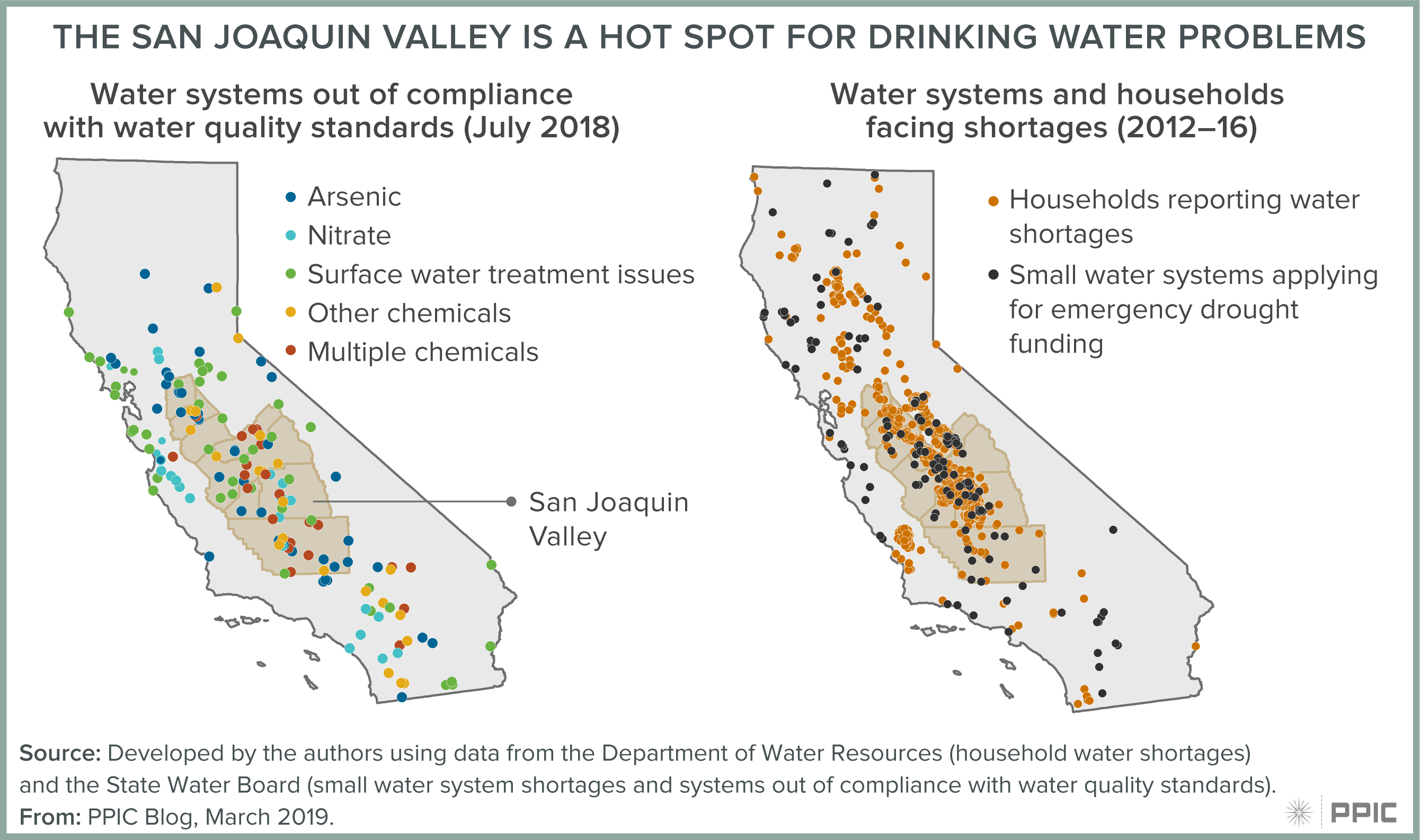
The theme of this Friday’s World Water Day is the lack of safe drinking water that affects many millions of people worldwide. Here in California, the San Joaquin Valley is a hot spot for unsafe drinking water. The region has more than half of all public water systems that are out of water-quality compliance in California, but just 10% of the state’s population. In addition, chronic decline in groundwater levels has caused drinking water wells go dry in a number of the region’s communities. We talked to Veronica Garibay—co-founder and co-director of the Leadership Counsel for Justice and Accountability—about ways to ensure community involvement in water management decision-making processes.

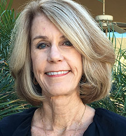
photo - Veronica Garibay

PPIC: What is key to understanding the valley’s safe drinking water crisis?

VERONICA GARIBAY: Water management is a particularly opaque and complex process, and past decision-making processes related to land use and water management failed to meaningfully include disadvantaged community voices and address their needs.

Climate change brings major risks to our water resources. The communities that are already the most vulnerable to the impacts of climate change—including water shortages during droughts, worsening water quality, flooding, and other problems—will see their vulnerability exacerbated. We have to change the way we manage water resources to adapt to these changes.

We have to bring our most vulnerable communities into these conversations, prioritize their needs, and make sure they, too, have decision-making authority over policy, programs, and projects.

Disadvantaged communities have been at the forefront of the progress we’ve already made on providing safe drinking water. They led the charge that gave the State Water Board the authority to consolidate small systems into larger ones, brought emergency funds to communities whose wells went dry during the drought, and led to the board’s establishment of the Office of Sustainable Drinking Water Solutions. Now their leadership is building momentum around the proposed safe and affordable drinking water fund, which would provide much-needed resources to pay for ongoing operations and maintenance costs and capital projects to ensure safe drinking water.

figure - The San Joaquin Valley Is a Hot Spot for Drinking Water Problems

PPIC: The Sustainable Groundwater Management Act requires local agencies to protect water quality while balancing groundwater supplies and demands. Why is it important for disadvantaged communities to participate in this process?

VG: Water is a critical resource to all of us, and the most vulnerable people should have a say in its management. Communities have a lot to contribute and need to be part of the solution. As a region we need to democratize the process and make sure that all interests are considered.

We’re working to ensure that planning for groundwater sustainability is more inclusive by encouraging groundwater sustainability agencies to establish authentic and meaningful space for direct community input and engaging communities most vulnerable to water quantity and quality issues in the region. We want to see sustainability plans that incentivize programs, policies, and projects that support safe drinking water and benefit households in disadvantaged communities.

PPIC: Are there good models for participation in the process?

VG: The North Fork Kings groundwater sustainability agency (GSA) has established a rural community advisory committee. It helps bring disadvantaged rural communities into the process to develop a sustainability plan. That’s a good step in making sure communities are providing direct input.

And the Madera GSA is encouraging all stakeholders to learn from each other and talk to each other. They’re making sure a variety of stakeholders get in the same room to learn how decision making on water affects different groups, and how we can shape solutions together.

We’d like to see more GSAs give some authority to disadvantaged communities and meaningfully build space into their processes for communities to participate.

Equal access to information is also key—what’s being presented at meetings should be accessible and in different languages if needed. And we need to ensure there is space to give feedback and that this feedback is reflected in the final sustainability plans.

These efforts will take work. Organizations like ours, and Self Help Enterprises and the Community Water Center, have all offered to collaborate with GSAs and help them engage community participation. The state has provided some funds for community engagement as part of its support of the SGMA planning process. But GSAs will also need to budget for equity—plan for and allocate resources to make sure they’re intentionally engaging communities.

Watch a video of Veronica Garibay and other panelists discussing water supply and water quality management in the San Joaquin Valley

The Challenges of Changing Land Use in the San Joaquin Valley

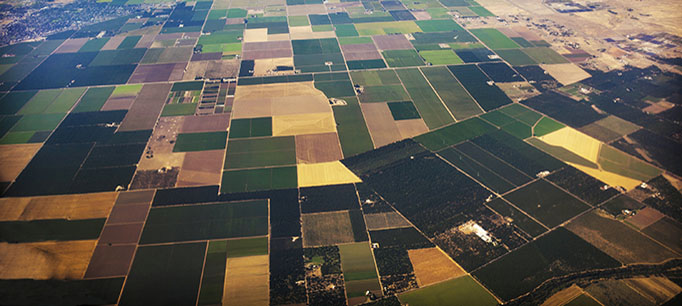
Implementing the state’s Sustainable Groundwater Management Act—which requires overdrafted groundwater basins to achieve balance between supply and demand by the 2040s—could require taking at least 500,000 acres of irrigated cropland out of production in the San Joaquin Valley. While some lands will be converted to uses such as solar energy, groundwater recharge, and restored habitat, there are no current plans for most of this acreage. We talked to Soapy Mulholland, president and CEO of Sequoia Riverlands Trust, about this impending challenge.

photo of Soapy MulhollandPPIC: What key challenges does this land use transition pose?
Soapy Mulholland: The challenges of managing this amount of land if it’s fallowed piecemeal―5 acres here, 30 there—are huge. A hodgepodge of retired lands would be very difficult to manage and restore.

When farmland is left bare it can cause dust and weed problems, so it will need cover crops. Finding the right cover crops that don’t use a lot of water is likely to be expensive. Grazing can help keep weeds down, but that requires fencing and most of the valley’s farms aren’t fenced.

PPIC: What are some top priorities for ensuring these lands are well managed?

SM: What we need is a vision for how to retire large blocks of land. That will require a “banking” system that pays farmers for retiring land and allows other farmers to purchase credits for a portion of the retired lands’ water, which they can then use on their own lands.

Let’s say you are a highly productive walnut farmer. You don’t want to fallow any of your 100 acres, so you would prefer to purchase a block of unproductive land to get water credits and keep your farm going. It’s a form of water trading. We need to figure out systems for how best to do that.

The idea is to buy farmland with low productivity, retire it, and link it to existing natural habitats. This could extend wildlife corridors from other parts of the region and allow for landscape-scale conservation on the valley floor. For example, there is a lot of potential to do this with less-productive lands at the edge of Tulare Lake Basin—we could conceivably get blocks of land 30,000 to 40,000 acres in size there.

We’ll need an organization or agency that can buy up retired lands—and systems in place to help manage them. We’ll also need a broad coalition of expertise, for example, appraisers and bankers to keep track of credits, and land managers with expertise in open space. We’ll need sophisticated systems that address all the different rules and regulations in California, and that connect all the various stakeholders and agencies that will be involved. And we’ll need funding—both for planning and for the systems themselves.

PPIC: Are there good examples of ways to use the idled lands?

SM: The establishment of solar plants in the Carrizo Plain area in eastern San Luis Obispo County is a good example. The solar companies had to figure out how to mitigate for impacts to habitat and agricultural land. They ultimately purchased more than 30,000 acres of rangeland and dry farmland, and entrusted future management to state agencies or land trusts (including our organization). Using grazing and other management techniques, these lands are now being restored, and even the areas under solar arrays are being managed to benefit at-risk species like the San Joaquin kit fox. Connecting these lands with the nearby Carrizo Plain National Monument offers even greater opportunities to multiply the benefits that each protected area provides on its own. It’s a good example of how to manage large parcels for multiple uses: habitat, agriculture, and renewable energy.

We need more pilot projects to set examples and figure out how best to do this. In the San Joaquin Valley, projects could focus on converting large parcels of retired farmland to semi-irrigated pasture or native grassland, with management in the hands of experienced land trusts. This approach could have benefits ranging from carbon sequestration and natural groundwater recharge to improved air quality and habitat for threatened and endangered species. As in Carrizo, landscape-scale conservation could produce much better outcomes than disconnected projects.

Bringing our region’s groundwater use in line with sustainable supplies will require significant changes in land use, agriculture, and water markets. Figuring out the right answers is likely to push all of us―farmers and ranchers, urban dwellers and conservationists alike―out of our comfort zones. But a coordinated approach to farmland retirement offers opportunities for landscape-scale conservation that can benefit people and nature.

Watch a video with Soapy Mulholland and other panelists discussing planning for water and land use transitions in the San Joaquin Valley

A Winning Approach for Managing Groundwater in the San Joaquin Valley

The San Joaquin Valley is in a time of great change. Decades of groundwater overuse have caused drinking water and irrigation wells to go dry, increased the amount of energy required to pump water, harmed ecosystems, and reduced the reserves available to cope with future droughts. Groundwater overdraft has also caused land to sink, damaging major regional infrastructure, including canals that deliver water across the state.

These problems spurred the enactment of the Sustainable Groundwater Management Act (SGMA), which requires local water users across California to bring groundwater use to sustainable levels by the early 2040s. With California’s largest groundwater deficit, the San Joaquin Valley is ground zero for implementing SGMA.

Although the region will reap many long-term benefits from ending overdraft, the transition to groundwater sustainability will be challenging and costly. The good news is that some approaches can greatly reduce the costs of bringing basins into balance.

The valley faces a groundwater deficit of nearly 2 million acre-feet per year (11% of net annual water use). To close the deficit, local agencies will have to augment their supplies, reduce their demands, or use some combination of these two approaches.

Our new report shows how a portfolio approach—with supply investments that farmers can afford and tools that increase flexibility for managing demand—offers a winning combination. The most promising supply options are to capture and store more local runoff, especially in groundwater basins, and to increase water imports by managing the system differently. On the demand side, increasing water trading—both within and across groundwater basins—can significantly mitigate the impacts of reducing water use, by allowing farmers to maintain the crops that generate the most revenue and jobs.

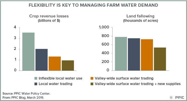
As the figure below shows, if farmers have no flexibility to trade water or adapt crop choices, ending overdraft without new supplies would require fallowing 780,000 acres—about 15% of the valley’s 5.2 million acres of irrigated cropland. It would also cause crop revenue losses of about $3.5 billion per year—roughly 17% of current crop revenues in the region.

figure - Flexibility Is Key to Managing Farm Water Demand

But if farmers can make flexible crop choices and trade ­water within local groundwater basins, fallowing would decline slightly, and crop revenue losses would fall by nearly half (to $2 billion per year). And with broader, surface water trading across the San Joaquin Valley, farmers in the south would buy some water from the north, where it is more abundant. This also would not change the amount of fallowed acreage by much, but it would further reduce the need to fallow the most profitable fruit, nut, and vegetable crops—lowering revenue losses by nearly two-thirds (to $1.3 billion per year).

Finally, a portfolio approach combining water trading and cost-effective supplies would reduce crop revenue losses by three-quarters (to $0.9 billion per year). The new supplies would also make a large dent in the need for land fallowing, which would fall by nearly one-third (to 535,000 acres).

Using a portfolio approach to achieve groundwater sustainability and avoid economic disruptions in the valley will require coordinated efforts among local, state, and federal agencies. The most pressing priorities are those related to expanding groundwater recharge and water trading, including:

  • Assessing infrastructure needs and modernizing water operations
  • Incentivizing recharge on farmlands
  • Clarifying how much water is available for recharge
  • Developing a healthy local trading culture
  • Facilitating state and federal approvals for trading and banking

Finally, to reap the most benefits from recharge, trading, and other tools, local entities will need to collaborate both within and across basins. Since the valley has more than 120 groundwater sustainability agencies for its 15 groundwater basins, overcoming institutional fragmentation will be key to success.

Video: A Conversation with Chief of Staff Ann O’Leary

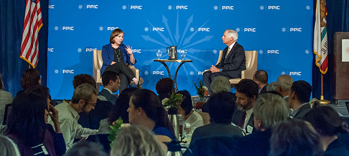
As the Newsom administration lays out its initial plans, PPIC invited chief of staff Ann O’Leary to discuss some of the governor’s top priorities. In a wide-ranging discussion with PPIC president Mark Baldassare last week, O’Leary identified the “cost crisis” in California as one of the main challenges that Governor Newsom plans to address.

“By ‘cost crisis,’ I mean how do we make sure that people in California can have affordability and the opportunity to really take advantage of the California dream?” O’Leary said. “I think too many people in California are really seeing that slip away. They’re not able to afford homes, they’re not able to afford child care, and they’re not able to pay for college for their children as they grow older.”

O’Leary pointed out that confronting this cost crisis would take many forms, such as taking on health care affordability, investing in “cradle to career” education, and addressing housing production and rising rents.

She underscored that the governor’s first proposed budget reflects his vision for promoting affordability and opportunity while ensuring the state’s long-term financial stability. Newsom’s plan includes a mix of one-time and ongoing funding as well as a robust rainy day fund, but “we also go further than that. We have a reserve fund for the safety net, and we also look at how we could use some of the surplus to pay down pension liabilities.”

The governor has also focused on other key challenges—for example, responding to wildfires and tackling the unmet need for safe drinking water in many parts of the state.

On wildfires, O’Leary noted that the governor wants to “make sure that we’re continuing with those recovery efforts to help communities that have been harmed, but also to prepare for future wildfires.” On drinking water, O’Leary said that the governor has already worked with the legislature to provide $20 million in emergency funding to address this issue.

Navigating the PG&E bankruptcy filing is another immediate priority. O’Leary said that over the next 60 days the governor’s team would be creating a roadmap for the state to “protect wildfire victims, protect employees who are out there every day trying to make sure we’re safe, and make sure fundamentally that we have safe and affordable power and that we’re meeting our clean-energy goals.”

O’Leary also discussed the federal-state relationship and how the governor plans to manage it. While pointing out that the state and federal governments need to work together as much as possible, O’Leary also underscored that California must stand up for its values when fundamental disagreements exist, especially on issues such as immigration and family planning. “These are differences of opinion. And it’s a needle we have to thread, but we’re going to do our best.”

Video: Water and the Future of the San Joaquin Valley

The San Joaquin Valley is at a critical juncture in determining its water future. California’s largest agricultural region is ground zero for many of the state’s most difficult water management problems, including groundwater overdraft, drinking water contamination, and declines in habitat and native species.

A state mandate to bring groundwater use to sustainable levels will have a broad impact on valley agriculture and the regional economy in coming years, likely including some permanent idling of farmland.

The PPIC Water Policy Center assembled a group of regional experts last week for a half-day public event at Fresno State to discuss three overarching challenges: balancing the valley’s water supplies and demands, addressing water quality problems, and planning for beneficial water and land use transitions.

Ellen Hanak, director of the PPIC Water Policy Center, launched the day’s discussions with a summary of the valley’s water-related challenges and approaches that could help address them. “The valley faces unprecedented challenges and a lot of change,” she said. Drawing from a new PPIC report on the valley’s water future, she noted that an all-hands-on-deck approach will be needed as the scope of the problems can’t be addressed farm by farm. “The most promising approaches are those that increase flexibility, provide incentives to encourage folks to make decisions that are beneficial, and can be done cooperatively.”

The first panel focused on ways to balance supply and demand in the face of an annual groundwater deficit of nearly 2 million acre-feet a year. Some of the approaches discussed included assessing opportunities to use infrastructure and farmland to augment groundwater recharge, crediting landowners for helping to recharge aquifers, and providing flexibility to farmers—for instance with water trading—so they can avoid fallowing the most profitable crops.

“The goal is to put as many tools into the hands of the landowners to give them the opportunity to manage [groundwater sustainability] to the best of their ability,” said Eric Averett of the Rosedale-Rio Bravo Water Storage District.

The second panel tackled the complex and pressing groundwater quality issues the valley faces—from resolving safe drinking water problems in poor rural communities to addressing ongoing nitrate and salt contamination of groundwater and soils. Key challenges include finding ways to pay for safe drinking water for affected communities; identifying cost-effective approaches to reduce nitrate contamination, especially on farmlands managed by dairies; and ensuring that flooding farmland to recharge basins doesn’t harm groundwater quality.

The final panel explored ways to manage fallowed land to get multiple benefits for people and nature. “We can think about ways to manage recharge basins to create wildlife habitat,” said Nat Seavy of Point Blue Conservation Science, one of the authors of the PPIC report. “There are opportunities to restore retired land and create habitat for San Joaquin desert species, and we can restore floodplains in a way that provides flood benefits for people.”

A common theme to the day’s discussions was finding ways that local stakeholders can work together on these difficult problems. As Hanak noted, “The leadership on this has to come from the valley. State and federal support can help, but folks in the valley will need to drive the change.”

We invite you to watch the videos from this event and hope you find the discussions helpful:

Commentary: A Balancing Act for the Water-Stressed San Joaquin Valley

This commentary was published in the Fresno Bee on February 21, 2019.

The San Joaquin Valley is on the brink of a major transition as it seeks to balance its groundwater accounts. California’s largest farming region has the state’s biggest groundwater deficit—almost 2 million acre-feet per year by our estimates. To put it in context, that’s about one Don Pedro Reservoir’s worth of water a year.

Read the full commentary on fresnobee.com.

Commentary: Delta Interests Should Seize the Opportunity to Cease Water Fights

This commentary was published in CALmatters on February 21, 2019.

The Sacramento–San Joaquin Delta is a major source of water for cities and farms across the state, and a major source of water conflict.

In a Sacramento Bee editorial two years ago, we and our colleague Brian Gray promoted a grand compromise for the Delta. We suggested that the three broad interests fighting about its future—water users, environmental groups, and Delta residents—give up something in order to reduce conflict and make progress. During his first state of the state address, Gov. Gavin Newsom opened the door to just such a compromise.

Three interrelated issues in the Delta are in tension and need resolution:

  • First, the reliability and quality of its water are in decline. More than 25 million Californians and 3 million acres of farmland rely on the Delta for a portion of their water supply.
  • Second, ecosystems in its watershed are changing, harming fisheries and threatening extinction of some native species.
  • Finally, many of the 1,100 miles of fragile levees that protect people’s farms and homes are in need of costly upgrades.

Climate change and rising sea levels are making all of these problems worse.

Gov. Jerry Brown’s WaterFix program aimed to solve the supply problem by building two large tunnels underneath the Delta to route Sacramento River water to Bay Area and Southern California cities and San Joaquin Valley farms.

The project’s size, and its potential for ecological harm if mismanaged, made it untenable to most Delta residents and environmental groups. It also was very costly, with uncertain financing prospects. A stalemate developed in which none of these interrelated issues—water supply, ecosystems, levees—could be adequately addressed.

Gov. Newsom has changed that equation by proposing to build one tunnel, not two.

A single tunnel would perform almost as well as two tunnels, particularly when operated in tandem with the existing pumps in the south Delta. It would cost substantially less. And it would give assurances to environmental groups and Delta residents that the project would not create the large impacts many fear.

Environmental groups should take this opportunity to sign on to a new approach for managing the Delta.

This would involve focusing less on the volume of flows dedicated to protecting endangered species and more on how flows and habitat—managed together—can improve ecosystem conditions.

Doing this well will require major commitments to habitat restoration from the state and water users. It will also require new approaches to managing environmental water.

We recommend establishing ecosystem water budgets that can be stored, traded, and flexibly allocated. This makes the environment a partner in water management rather than merely a constraint. Reliable funding, good governance, and robust scientific support will be essential components of this package.

There’s an opportunity for the new governor to move forward on the ecosystem issue as well. The State Water Board is revising its Water Quality Control Plan for the Delta.

Governors Brown and Newsom have stated their desire that water users and environmental groups develop negotiated agreements as an alternative to new environmental flow regulations from the board.

Done well, such agreements have the potential to create flexible allocations of water for the Delta ecosystem. The clock is ticking. Getting these negotiations completed is critical to resolving the Delta’s problems.

The administration also must address the future of the Delta’s fragile levees. Some are essential for managing water quality, and all are under threat from climate change, sinking land, and earthquakes. There is an opportunity to build upon the recently completed Central Valley Flood Plan and the Delta Stewardship Council’s efforts to prioritize investments in levees. A comprehensive, reliably funded plan that accounts for the multiple threats to levees is sorely needed.

In California’s complicated water wars, some may consider “compromise” synonymous with surrender. But those who insist on fighting will only be rewarded with more fights. Progress happens when parties give up something to get what they really need. By proposing to build one tunnel instead of two, Governor Newsom has opened the door for a grand compromise in the Delta. The Delta’s many interests should seize this opportunity.

Connecting the Drops in Watershed Management

The interrelated nature of water issues has given rise to a management approach that integrates flood control, environmental water, and water supply. The Yuba Water Agency manages its watershed in this kind of coordinated manner. We talked to Curt Aikens, the agency’s general manager, about the lessons they’ve learned from this “integrated management” approach.

PPIC: Your agency manages the watershed for hydropower, water supply, flood control, and ecosystem health. What are some key elements to making it all work together?
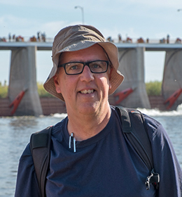
Curt Aikens: I think the most critical elements to making this work for us are employing science and broad collaboration to sustainably manage all of the resources.

We try to make the most of every drop of water we touch—this infographic highlights how we do that. Our water provides recreation, carbon-free electricity, habitat for fish and wildlife, and a sustainable water supply for farmers and the 80% of our population that relies on groundwater for drinking water. In drought years, we transfer water to the state for use in the Central Valley and Southern California. We use the proceeds from those transfers and from hydropower sales to invest in reducing flood risk in Yuba County and other environmental, water supply, and public safety projects.

In managing this integrated system, we’re fortunate that our agency’s boundary fully contains our groundwater basins and most of the Yuba River watershed. The river flows right down the middle of the county.

We worked hard to get where we are today. In the 1990s we were involved in a contentious debate with conservation groups and state agencies over environmental flow requirements for the Lower Yuba River to support salmon and steelhead trout. To resolve the situation, we developed a collaborative, science-based settlement called the Yuba Accord. This agreement, which improved salmon and steelhead habitat, is a foundation for our success, because it helped us solve a number of problems collaboratively.

We try to ensure that everything we do has multiple benefits and comes from a strong collaborative effort. The Feather River Setback Levee is a great example of that. After Yuba County flooded in 1997, we commissioned a comprehensive flood study that presented half a dozen options to reduce future risk. Working with local conservation groups, we eventually settled on a program to set the levees back and strengthen them. This significantly lowered flood risk while producing ecological benefits for the river. The community gained a new, stronger levee, a significantly lower flood risk, and real ecological benefits.

PPIC: Is it harder to address multiple problems with one project?

CA: Today, it’s actually harder to implement a project with a single purpose. We live in a world with multiple interests, and we’ve found that multipurpose projects are a much better way to get things done. The Yuba River has more human impacts than most other rivers in the state. So we try to get ecosystem benefits out of most of our projects, whether it’s improving fishery habitat in our flood control work or strengthening water supply management through a project to build forest health.

Collaborative, science-based initiatives cost more and take more time upfront, but in the end you can get better results and more durable, sustainable solutions.

PPIC: Can this approach work well for water agencies that share a watershed with other entities or have other complicating factors in how they manage their system?

CA:  I think it absolutely can. There are many examples of multiple jurisdictions working together to resolve common water or natural-resource challenges. For example, the work being done on the voluntary settlement agreements in the Bay-Delta has brought together a really diverse group of conservation and water interests working toward an innovative solution. This approach is collaborative and science based. It also presents the opportunity for fish and wildlife habitat creation, new flows to support fish, and funding to help finance these activities.

Collaborative agreements, rather than a mandated regulatory approach, offer much greater promise for California’s environment and economic stability. This is exactly our experience with the Yuba Accord.  Continued leadership from Governor Newsom and his administration can help California create a sustainable solution for the entire Bay-Delta watershed.

Colorado Drought Deal Close, But Not Done

Last week Arizona and California missed a deadline to submit final plans for how they will manage water shortages in the Colorado River Basin over the coming decades to prevent Lake Mead levels from dropping so low that water cannot be released from the dam. The other five states that share the river’s waters have already submitted their drought contingency plans. We talked to John Fleck—director of the University of New Mexico’s Water Resources Program and a member of the PPIC Water Policy Center research network—about the situation.

photo of John Fleck

PPIC: What is the drought contingency plan intended to do?

John Fleck: The key problem on the Colorado is that the basin’s water is over-allocated. It was really wet in 1920 when the allocation rules for the river were developed. So the rules allocated extremely large water shares to the “lower basin states”—California, Arizona, and Nevada—that hydrologic reality can’t support. We’ve been struggling ever since to come to terms with that reality.

The drought contingency plan is a voluntary program involving the lower basin states to decrease their use of the river’s water in an attempt to reduce the over-allocation problem. There’s an overall agreement describing the conditions that would require each state to use less water. Then each state has to have its own separate internal set of agreements on how to share those cuts.

There are a couple of different ways you can approach this over-allocation problem. The federal government can just reduce everyone’s allocation. Or you can have the water users themselves acknowledge the problem and agree to a voluntary, collaborative approach. The latter approach is far more likely to succeed, so I definitely think this was the better way to go.

Even though the lower basin states are close to having final plans, federal officials have said that “close isn’t done.” The states now have until March 4 to submit their final plans. No one wants to have an imposed federal solution—and I don’t think we’ll end up there—but it’d be better than doing nothing. The threat alone might push people to finish up.

PPIC: What are some important steps the states have agreed to?

JF: The agreements reduce water use in the lower basin by 1.5 million acre-feet per year; it’s a very big deal. Arizona has now agreed to a plan that could eventually reduce the Central Arizona Project’s flow of Colorado River water into the valleys of Tucson and Phoenix by nearly half of current levels. They did this voluntarily, without any litigation. That’s real progress. And Imperial Irrigation District (IID)—the biggest agricultural user of California’s allocation of Colorado River water—has already given up 500,000 acre-feet a year, which is a huge amount of water.

One of the complications of reductions in Colorado River water is the drying of the Salton Sea, which relies principally on runoff from farms in IID. California promised to mitigate the public health and environmental problems associated with the shrinking of the sea, particularly the air quality impact on poor communities. Solving this problem is a work in progress made more challenging by reductions in Colorado River water.

PPIC: Do you think the states’ plans go far enough, given the warming climate?

JF: We can’t be sure, because we don’t know how much impact climate change will have, on what time scales. Since we don’t really know where the bottom is for the Colorado River, hydrologically speaking, we don’t how far we’re going to have to go with water cutbacks in the long run. Drought planning is a really important step to prepare for a climate-challenged future—it creates a framework for deeper cuts.

It’s important to see the drought contingency planning as the latest development in the evolution of long-term management of the river’s waters. There are a bunch of unresolved problems—both hydrologic and institutional―and a lot of work remains to be done, but we can’t solve all these problems at once. Though drought planning is an incredibly important step, it’s certainly not the last one.

Fleck is a co-author (with Eric Kuhn) of the upcoming book Science Be Dammed: How Ignoring Inconvenient Science Drained the Colorado River, to be published this fall by the University of Arizona Press.